
It's ready! I was going to sit on it for a while, but what's the point really. I'm not seeing anything exciting coming up for the fall, and anything that does arise can just wait for 2011! My free time for any weather observing the remainder of the fall is quickly vanishing as it is so... just take it off my hands!
Definitely a more "artsy fartsy" DVD than previous productions with a ton of time lapse action.
Features the May 10 2010 Wakita, OK EF3, May 22 2010 Bowdle SD everything but the wedge, but plenty of pheasant in my grille chase, June 7 2008 Chicago area wedgefest with four separate massive tornadoes from one supercell, May 22 2008 high risk chase with four tornadoes filmed from close range and very rare video of the Fort Atkinson, Wisconsin tornadoes on July 22 2010. Plenty more tornado video, plus more for those seeking plenty of mother nature's eye candy including 100 mph tree uprooting RFD winds and a big ol' time lapse segment.
Asking $15 now, but will raise it to $20 mid-September. Shipping included.
I'll ship the first round out this weekend.
Ordering information, a complete list of included dates and some pretty pictures:
http://prairiestormmedia.com/PWX2010.html
I should add that I really prefer trading videos with other storm chasers. If anyone has a DVD from this year or years past just get at me somehow and we'll make a trade!
Tuesday, August 31, 2010
Sunday, August 29, 2010
DVD Production...
I just finished watching the completed version of my 2010 DVD. It wound up being a bigger production than I planned. What started out as a simple 2010 highlights DVD ended up being more of a 2010 highlights dvd + my favorites since 2007. Perhaps it was the insane year that I didn't really get to tap into, but it felt very empty with only my 2010 chases so I figured what the hell, and started editing some more and here we are. Included in that is the usual photography slide show, and a new segment played off the page on my main website called "WX in motion" featuring my favorite time lapse segments set to music.
The DVD definitely has a different feel than anything else I've produced, but I think those that enjoyed my past projects should still like this one. It's definitely a lot more artsy fartsy with a ton of time lapsing involved.
I plan to sit on it for a tiny bit to make sure no surprise events are going to jump on us, but I'll probably get impatient and throw the order information up shortly. looking at $20 per copy right now, but trades from other chasers are my favorite way to go. I don't make these guys to get rich (and couldn't if I tried), but because I just love playing with video and creating these guys for my own personal enjoyment (when I feel like reliving a chase, it's much easier to throw in my own DVD than dig through tapes!) and to get something to trade with other chasers out there because there's no better way to spend the day when it's snowing sideways outside than watching a buddy's chase DVD.
Unrelated to the DVD, check out this link I stumbled upon this evening.
http://www.wimp.com/solarsystem/
It's a time lapse of the discovery of every asteroid from 1980-2010. Pretty incredible once it get's going.
Weather wise, nothing much to discuss. It's warm and humid again. Looks like storms off and on Wednesday and Thursday but not convinced of any severe weather in the area. Not like I have time with a new semester in full swing now, but some lightning out the bedroom window would be something I wouldn't argue against.
Thursday, August 26, 2010


Tuesday, August 24, 2010
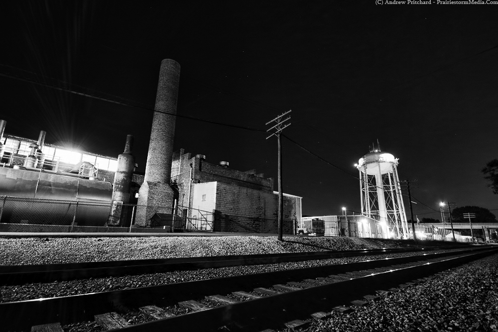
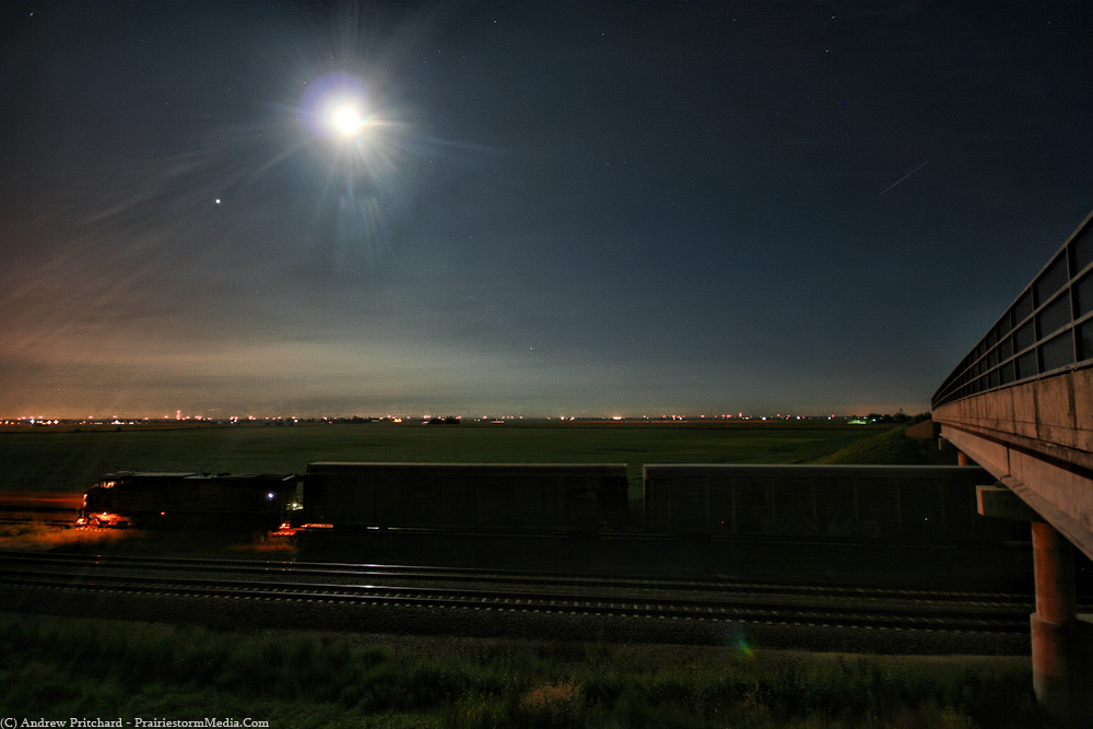
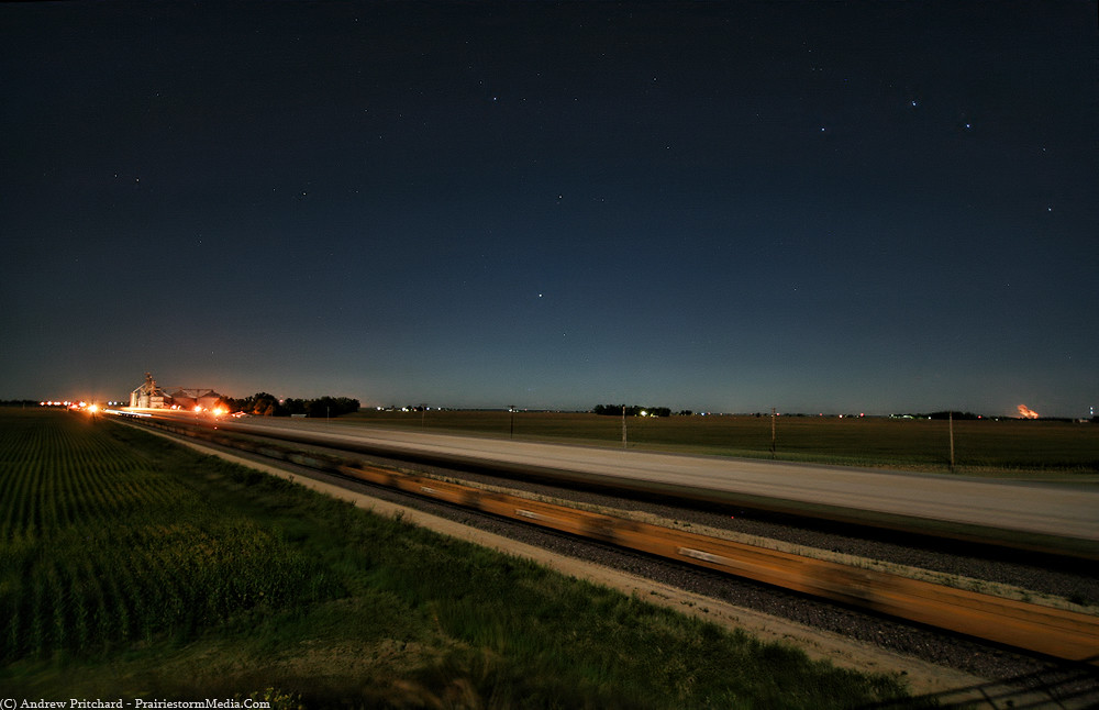
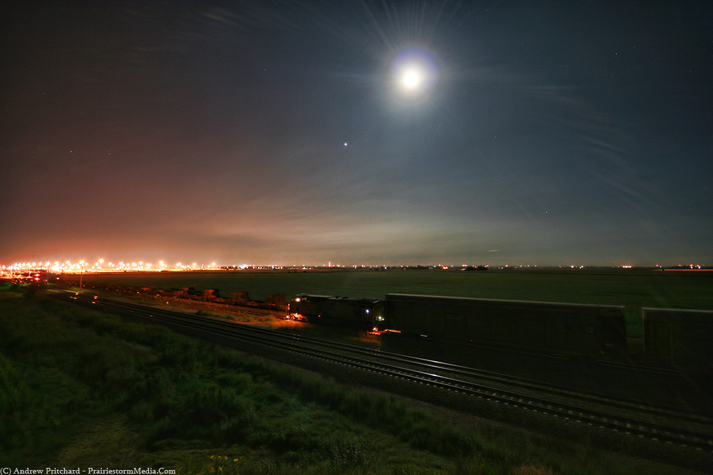
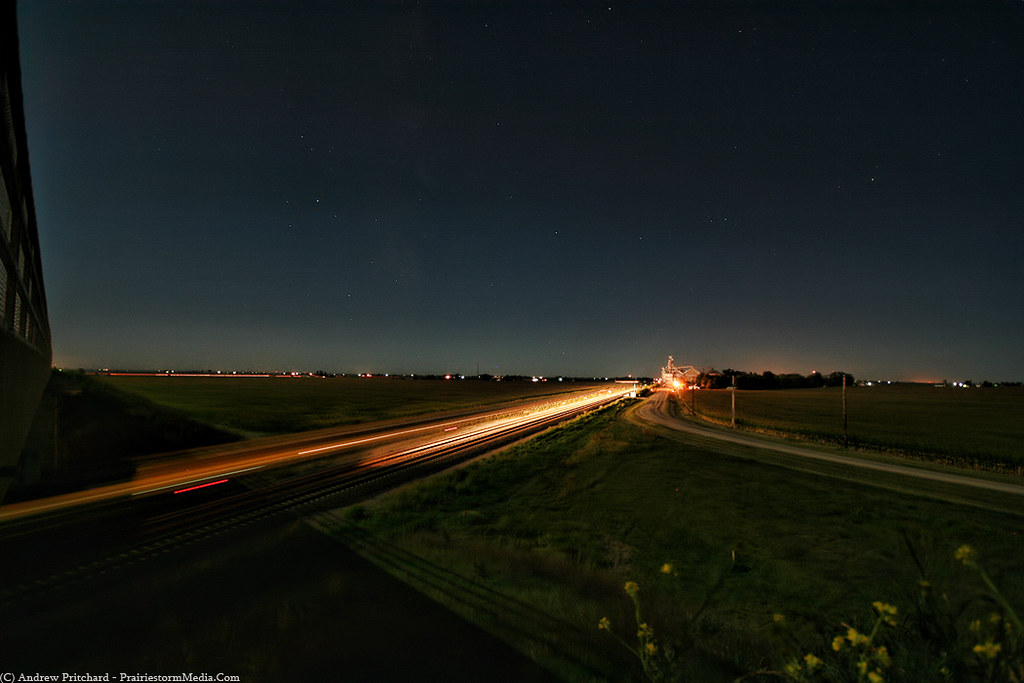
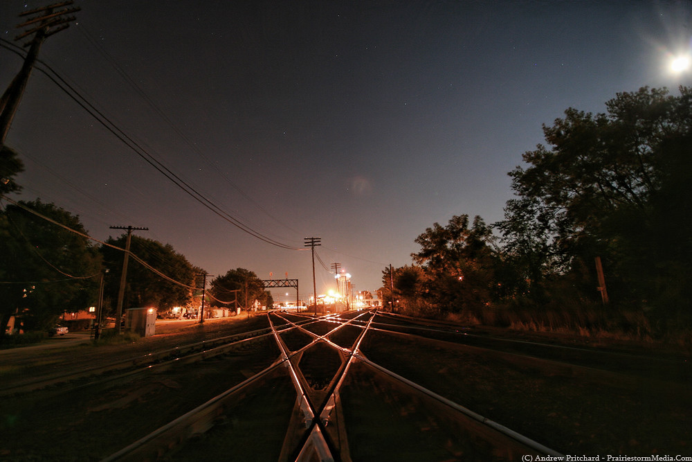
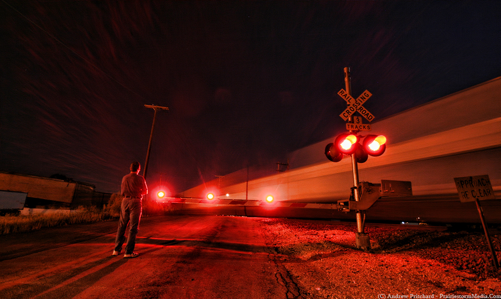
Trains under the full moon
Gilbert Sebenste and I headed out again last night to the Rochelle Rail Park for some night train observing. The full moon was nagging me to get out and shoot some photos as it was. Not a lot of explanation needed with these guys, so I'll shut up. We did manage to track down a much talked about bridge just beyond the Global 3 train depot, which was hopping even at 11 PM. The train depot... not the bridge. Anyway. Looking forward to some beautiful weather this coming week, albeit storm free. With classes beginning and a DVD to finish, I'll open the windows and you won't hear a peep out of me!


"The Diamonds". The junction of the Union Pacific and Burlington Northern.
This probably could have been composed better lighting wise, but it was tough balancing the two extremes of the dark night sky and the oh so bright sodium lights.
Again, I feel like I need a second attempt at this guy. Pretty awesome sign for an old abandoned restaurant along Hwy 38 west of Rochelle. I'll probably try this guy again at day time.

The bridge overlooking the Union Pacific as it enters the Global 3 facility.


One last train as we leave Rochelle and head home. Gilbert decided to get up and watch this one so I decided to sneak a candid shot as he did so.
Tuesday, August 17, 2010
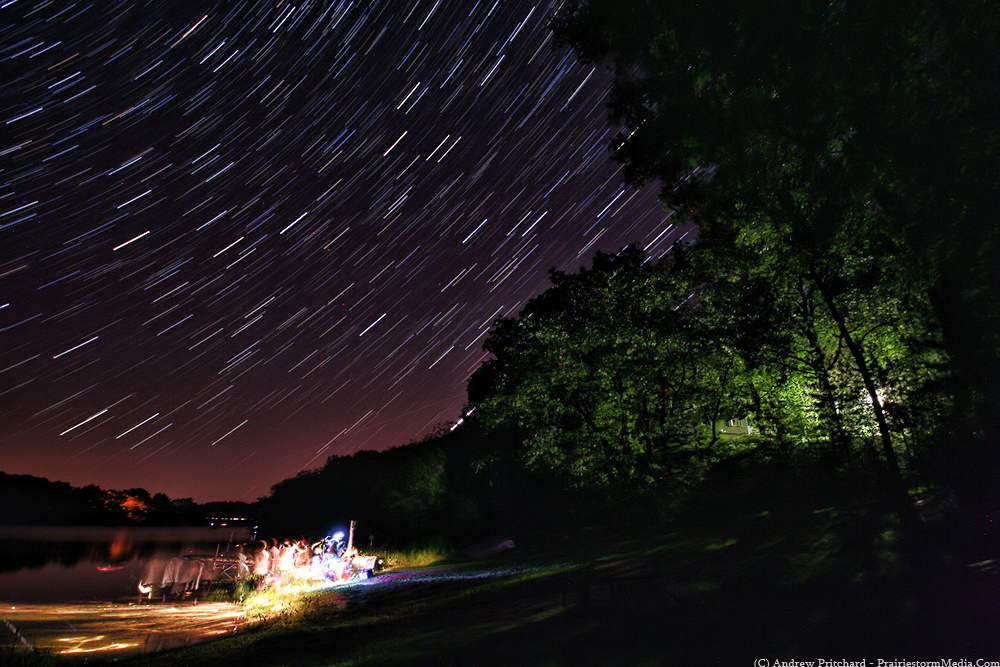
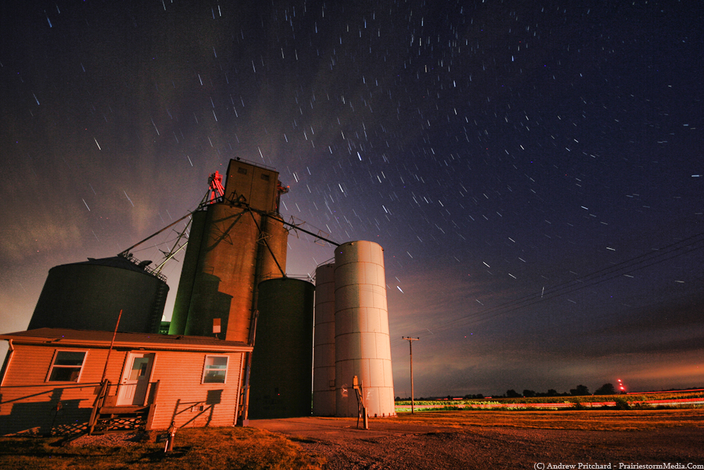
Wisconsin Star Trails
Back from a lovely four days up north at the lake cottage. Complete wtih a couple perfect nights for star trails, and a few bonuses! Included in the bonus were being buzzed by both a Stealth Bomber (can't remember ever actually seeing one of those in flight before) and a bald eagle! Also managed to find a really nice road bike that used to be owned by my grandpa decades ago that I've swiped to replace my crappy current bike for biking around town while the weather is still nice. I remembered as a kid seeing it tucked away in the garage but just thinking it was another piece of junk tucked away back there. However, now that my current bike is in shambles, it suddenly dawned on me to check for that thing and as luck would have it the thing was still there! In amazing condition too, so it's stood the test of time. A couple new tires, and a good wash and we'll be cruising in style again!
Anyway - the photos. I got about midway through the first big exposure over the lake and this time, no, not clouds, but a family coming down to fish complete with three flash lights setting up right on the beach where I was shooting. I about got pissed and stopped, interrupted for a 4th time in a row but decided to forget it and just continue with the shot and hope for the best. Turned out that it did work out, and is actually probably one of my favorite star trail images yet.

Second shot, I panned a little south a bit more towards the beach where the family was fishing. I don't love the shot as much as I hoped when shooting it, but it's a keeper too I suppose, and an overall great night of shooting. Could not have asked for better weather - temperatures in the 60s and perfectly clear skies. Getting a little excited for fall after this break from the 90s.
Saturday, August 14, 2010
Perseids Fail
Was busy until almost 3 AM last night believe it or not, so I only had a couple hours to catch the Perseids on their peak night before the sun would come up. Pretty big let down of a show. I saw a decent amount of meteors, but nothing at all spectacular. Perhaps my sights are set too high, but with the amount of night photography I regularly take part in I see my fair share of meteors, so on a night like this I expect some fun. I only captured a few meteors in the camera frame, and again, none were all that great. Then right on cue at 4 AM just like the night before a line of clouds moved in cutting my show short.
Here's a star trail image without a single meteor before and during the clouds moving into the frame forcing me to change angles. The image at the bottom is a plane, not a meteor.

Heading to Wisconsin first thing tomorrow morning. A cold front is moving thru so humidity levels will be cut way down, which should lead to much better optics for star gazing. Meteors I can't promise, but I'm hoping to get at least another good dose of star photography in over the weekend.
Thursday, August 12, 2010
Perseids; Day 1
Had trouble sleeping last night, so around 4 am I decided I still had another hour before dawn so I'd just kill some time and try and find a meteor or two. Skies were mostly clear overhead in Urbana, so I headed down Hwy 150 and stopped in the tiny "town" of Mayview, which is merely a row of homes along the highway between Urbana and St. Joseph. Upon stepping out of my car I was quite disappointed to see mostly cloudy skies all of a sudden! Discouraged, I still set the camera up and decided I was already out so I may as well try for something. I had a small window in the clouds to my northwest, so I settled for that. I only managed one meteor, and it was nothing to write home about. I poked around in the fog layers for a little before the sun rose, and eventually made my way back to town.
Hoping for more later this week. My band will be performing in town tonight, so I'll be occupied until around midnight. After that, perhaps I'll head out. Either way I plan on heading up to Wisconsin Friday. Looks like a stormy day and night on hand Friday up north, so while perhaps one could play with lightning it will not be ideal for meteor viewing. How about we'll just see what happens. I'll update as I'm able. Wireless coverage is sparse up near the lake, just how I like it; but this also means I won't be updating until I return to the Land of Lincoln more than likely.


Hoping for more later this week. My band will be performing in town tonight, so I'll be occupied until around midnight. After that, perhaps I'll head out. Either way I plan on heading up to Wisconsin Friday. Looks like a stormy day and night on hand Friday up north, so while perhaps one could play with lightning it will not be ideal for meteor viewing. How about we'll just see what happens. I'll update as I'm able. Wireless coverage is sparse up near the lake, just how I like it; but this also means I won't be updating until I return to the Land of Lincoln more than likely.


Wednesday, August 11, 2010
Afternoon pulsing convection
Early evening thunderstorms began erupting in western Illinois, and with a free evening I hoped something might spring up over here. Kept half an eye on satellite and radar thru the evening, and eventually did see some returns showing up in Champaign County. Tia and I ventured out south of town to do a little time lapsing. Was able to time lapse some downbursts, but nothing overly interesting. I did come away with a couple decent photos I suppose, wish would be the purpose of writing this.
Hoping for the main show later this week, which would be the peak of the Perseids meteor shower. I'm stuck in Champaign-Urbana until Friday, but hope to get north asap after that to catch the back half of the show. Plan is to head back north around Friday, and then eventually back up to the lake in Wisconsin over the weekend. The last few Perseid displays have been a huge downer, so with talk of an active show I'm hoping for better in 2010!


Same storm cluster now very grungy and weakening. Black and white with a lightning bolt shot from a parking garage in Urbana.

My Tia, observing with outflow blasting us in the face in the parking garage. Hoped for more in the way of lightning, but a decent way to end the day.

Hoping for the main show later this week, which would be the peak of the Perseids meteor shower. I'm stuck in Champaign-Urbana until Friday, but hope to get north asap after that to catch the back half of the show. Plan is to head back north around Friday, and then eventually back up to the lake in Wisconsin over the weekend. The last few Perseid displays have been a huge downer, so with talk of an active show I'm hoping for better in 2010!
Storm over southern Champaign County early in the evening. I'm sure they had some flooding in the Philo - Tolono region as this thing just sat there dumping rain and spitting out lightning bolts.


Same storm cluster now very grungy and weakening. Black and white with a lightning bolt shot from a parking garage in Urbana.

My Tia, observing with outflow blasting us in the face in the parking garage. Hoped for more in the way of lightning, but a decent way to end the day.

Thursday, August 5, 2010
Smoke visible from fires in British Columbia
Thanks to Gilbert Sebenste for helping me figure this one out. When checking the visible satellite imagery for the region I noticed a long band of "haze" stretching over parts of the upper midwest, from Minnesota into northern Illinois. It appeared to be smoke, or dust, but I wasn't sure what the original source was. I was unaware of the major fires going on at the moment in British Columbia, which would explain it!
http://www.cbc.ca/canada/story/2010/08/05/bc-fires.html
Here's the initial regional satellite image that made me scratch my head:

Zooming out to the national picture the source is plainly visible!

http://www.cbc.ca/canada/story/2010/08/05/bc-fires.html
Here's the initial regional satellite image that made me scratch my head:

Zooming out to the national picture the source is plainly visible!

DVD Production...
It has begun.
I have really high hopes for the 2010 edition of my PWX 20XX DVD series. While I was unable to get away from home as much as some and didn't bag as many epic tornadoes as I sure wish I had in 2010, I still managed probably my top overall year as far as documenting a huge variety of all things extreme and beautiful in weather, in all desired formats; time lapse videography, intense storm chasing footage and of course still photography.
This year's production will be a bit different than year's past, but I think it should go over pretty well with those of you familiar with my productions. I'm really excited to sink my teeth in and get going. By getting started early I'm hoping to avoid releasing the DVD after Christmas as I usually do. Hoping to get things more or less ready to send out sometime early in the fall. Probably aim to get most of it done some time in September so I can just sit on it for a few and make sure nothing crazy happens in the fall months and then send it on out.
Tuesday, August 3, 2010
Ehhh...
Well, if there's any positive right now it's that skies are almost entirely clear along and south of the outflow boundary and warm front left in the wake of morning thunderstorms that rocked us here in DeKalb from about 4 AM - 7 AM. Doppler estimates have around 1-3 inches of rain having fallen in the area, due to the slow moving nature and east-west formation I discussed last night.
My guess is that the better part of the day is ruled by subsidence and weak forcing leading to a mostly thunderstorm free day across the forecast target area of NW and NC Illinois. If there were a target, I'd still place it around the Peoria to LaSalle area sometime after 6-7 PM. The NAM among others are still insistent on the eventual development of an isolated thunderstorm or two along the residual boundary likely draping itself around the Interstate 80 corridor. Turning is present, but speed shear and lack of surface flow will likely prevent this from being a tornado day. That said, should a severe cell be able to root to a boundary an isolated tornado is possible with any brief mini-supercell storm. I don't have my hopes up, and will not be making the trip down there unless things appear much more certain.
It should be toasty, with temperatures south of the boundary easily reaching the low to mid 90's in central Illinois, with dew points in the mid-upper 70's. While overdone, the RUC estimates about 8,500 j/kg of surface based cape by evening. While not exactly representative of what will actually be present to work with, it's apparent the juice will be there. It's subsidence and capping, along with weak surface convergence that will keep a lid on things, and prevent explosive severe development that may otherwise be possible. I'll keep an eye on that Peoria to LaSalle line, but I don't expect much at all until at least very near sunset. That's when I believe an isolated storm or two is possible along that line.
The more likely scenario is that things remain dry through the daylight period, and we see another gradual increase in thunderstorm activity after sunset and another noisy and wet evening along the warm front in eastern Iowa and northern Illinois.
... and cue the 10 AM / First Tuesday test of the local tornado sirens! If only that were an omen...!
Monday, August 2, 2010
Marginal Potential in NW Illinois 8/3
Another marginal late-season tornado threat, this time in northwest Illinois. I'm going to be brief on this one, at least for tonight until things become more clear as to how they'll unfold.
Currently, an E-W oriented MCS is lined up near Interstate 80 from northern Illinois west into central Iowa. This slow moving sub-severe MCS, though at times capable of producing a heavy rain and an associated flooding threat should continue into the morning as it slowly chugs into north central Illinois. In it's wake, an outflow reinforced warm front will be located from southeast Iowa, into north central Illinois.
Instability along and south of the warm front should be more than adequate for severe convection redeveloping during peak heating, with MLcape values around 3000-3500 j/kg possible by mid-afternoon. Assuming minimal back building occurs thru the overnight hours and into the morning, in the wake of the MCS additional convection should begin to develop during the early afternoon. As this convection develops near the Quad Cities area and moves southeast it should attain severe levels. Given sufficient hodographs in the 0-3 km range, rotating storms are possible, at this point most likely in an area from Peoria to Bloomington, IL. The main limiting factor may be the 0-1 km range. Directional shear is conducive to storm rotation, but speed shear should be fairly limited so baring outflow boundary interaction (which is a valid threat) the storms may lack the *umph* to produce tornadoes.
All that said, given sufficient instability and the presence of the outflow reinforced warm front the afternoon hours warrant attention, likely along Interstate 74 from the Quad Cities towards Bloomington, as mentioned above.
If I were most concerned about one issue, it's the nagging feeling that tomorrow could end up a subsidence induced bust. If subsidence lingers in the wake of the MCS too long, this coupled with marginal forcing along the warm front due to weak surface flow, convection could be suppressed in the high shear zone until later in the period, if at all. Close attention will need to be paid to this issue as all the hodograph turning in the world will do us no good if we can't first develop a thunderstorm. Still, I'll pay attention.
Subscribe to:
Posts (Atom)


