In response to the recent sudden confusion amongst storm chasers in identifying what is and is not a tornado (or perhaps there is no confusion, only a case of tornado-count-envy) I've decided to create a handy little image glossary to which you may compare your images to, in order to decide if what you bagged the other day was indeed a tornado!
Tornado! We'll start with an easy one. Note the wide area of convection extending from the cloud base to ground level. This is a good indication you are viewing a tornado! Congratulations, you
are currently viewing a tornado!
 Tornado!
 Note the condensation cloud extending ALL the way from the thunderstorm base to the ground, with a debris cloud at ground level. This is a good indication that you
are currently viewing a tornado!
 Tornado!
 This one is tougher. There is a defined funnel cloud, but it does not fully extend to the ground. But look at ground level, there is indeed a small condensation vortex indicating that damaging rotating winds are reaching the surface indicating, you
are currently viewing a tornado!
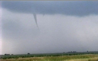
 Funnel cloud
. NOT a tornado. While this is a good indication you may see a tornado soon, this is not conclusive evidence that you have a tornado in progress. The storm is rotating, but it is likely not making it to the surface. This is a cool catch in itself, so you might as well call it as it is; a funnel cloud. Sorry, you
are not currently viewing a tornado.
 Wall cloud
. NOT a tornado. A wall cloud is another good indication you may see a tornado with your storm and that there is healthy updraft and potential rotation (a topic for another day) but is not an actual tornado. Note the time of day and distance in this image, as it helps makes things a little harder to see. The complicated viewing location does not however mean you should assume a tornado is in progress. Hard to see storm features do not equal a tornado. Sorry, you
are not currently viewing a tornado.
 Hard to see wall cloud.
 Tornado?! Note the lack of a clear view of ground level. Hills and trees will occasionally block your view of the surface under the wall cloud... this is actually NOT a tornado. Just a low hanging wall cloud in a location where a view of the ground is not possible. This does
not mean you should be claiming a tornado in progress.
Obscured view. Do not yet post on Stormtrack that you bagged a tornado.

Unobscured view of the same wall cloud. Sorry, you were
not currently viewing a tornado.
 Gustnado.
 NOT a tornado. Wow, look at all that dust! Surely I'm seeing a tornado now! Note the linear cloud base indicated by the backside of an outflow dominant storm complex. Often times linear outflow driven storms will have a strong surge of air along the leading edge that will kick up dust, that will at time exhibit weak rotation. The lack of rotation at the cloud level will indicate that this dusty area is overall, harmless.
This is also not to be confused with the
"dust whirl". Often times near a wall cloud or under the base of a violent supercell thunderstorm an area of dust may be kicked up. This is under a rotating storm, surely this must be a tornado, right? Often times, no. The underside of a supercell thunderstorm is very chaotic, with wind currents of all sorts heading in different directions. Dust can be kicked up for any sort of reason other than being a tornado in progress, so please, evaluate your situation a little more before calling in a tornado each time you see a dust whirl. Sorry, you
are not currently viewing a tornado.
 Shelf cloud.
 This is
not even a wall cloud or mesocyclone related, so, please do not tell me any dust you saw under this was a tornado. This laminar cloud structure will likely occur on the leading edge of a linear outflow driven complex of storms and may indicated damaging winds approaching your area, but is one of the best signs that you will not be seeing a tornado in the near future on that storm. Sorry, you
are not currently viewing a tornado.
 Multiple Vortex Tornado!
 You
are viewing a tornado! However, this area of multiple-vorticies is NOT many many tornadoes. One experienced tornado chaser lost much respect from me when he reported one long track multiple vortex tornado as over 20 &*^@ separate tornadoes. Yes you are viewing a tornado. No, you
are not viewing 20 tornadoes.
 Tornado!
 But wait, look at the copyright. I did not take this photo. I was on the storm, and was looking that general direction. HOWEVER, I
did not have a view of the tornado from my vantage point.
Being on a storm that has a tornado reported, and looking in the same general direction but having no idea a tornado is in progress, but later finding out that one was reported that you could not see does not equal seeing a tornado. Sorry, you
did not view a tornado. There is no such thing as hindsight chasing.
All images on this blog are my own (except the above image, courtesy of Dick McGowan of TornadoLive.com) and should not be reproduced or used without my possession. You may however, share this blog at your own will with your own tornado-identification troubled friends!







 Posts
Posts


