I'd intended on doing this once for every day during the entire month of February, but the blizzard distracted me during the first couple days. My plan originated with simply going through old folders filled with photos from each storm chase. I never delete anything, and after each chase generally just quickly thumb through the folder and post only a handful of photos, maybe four or five out of upwards of 100. The rest just lay dormant, and never see the light of day again. Eventually, I get bored and start rifling through each folder and sometimes a photo catches my eye and I wonder why I never chose to upload it. This whole process got me on a roll and I began shuffling through every single folder picking out a photo or two from each day that could have made the cut but slipped my eye for whatever reason. I gathered up a decent collection, and my plan has been to post one photo with a little story behind it each day through the month of February. This month is when I typically start really craving warm temperatures and bubbly cumulus clouds. I commonly call it the "February Itch". I typically call March 1st the kick off of severe storms season, as it is the official starting date of meteorological spring. Whether or not severe weather occurs during early March is not always the case, but it's when I consider it reasonable to start getting excited about the prospects.
Anyway, the point of this post is not about how often storm chasing in March is fulfilling (not often!) but to post photo #1 from the "Missed Photos" archive, and to keep plowing ahead toward Meteorological Spring 2011!
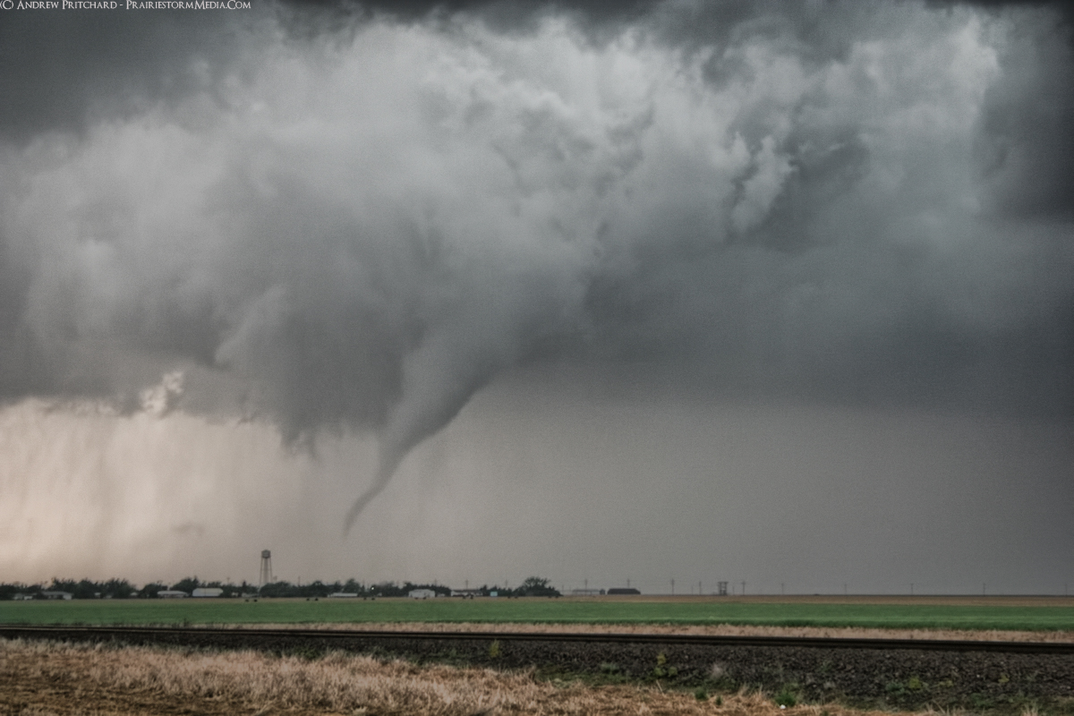
The first photo in the series is from May 22 2008, in western Kansas. Mark Sefried and I witnessed four tornadoes that day right near Interstate 70. Supercells initiated early in the afternoon, but took several hours to organize. I was worried we would be looking at the dreaded High Risk bust, but as if someone flipped on a light switch, the day went mad. Mark and I intercepted a supercell near Grainfield, KS and it immediately went tornadic. It produced a beautiful funnel cloud that taunted us for near 5 minutes dancing around before actually making ground contact. You get a classic funnel cloud and immediately get the "I'm about to see a tornado!" adrenaline rush. Then, the funnel cloud taunts you by never touching the ground for a period of minutes and you begin wondering if you're just going to walk away from the day with a funnel cloud aloft! Eventually, sparing the town of Grainfield the tornado finally extended toward the ground in a snake like fashion.
Photo #1 in the series shows the Grainfield, KS tornado moments before it makes full condensation contact with the ground, complete with a classic RFD clear slot.


No comments:
Post a Comment