Friday, July 23, 2010

Lightning and yesterday's video...

Just figured I'd post a quick video from yesterday.


Shortly after Tia and I returned home and I had just sank my teeth into looking over the photos and video from the day my phone rang, which ended up being Gilbert Sebenste wanting to go out and do some local night chasing with a line of storms coming into DeKalb County. The storms ended up petering out as they entered the area, but I still managed a decent shot or two as the line moved in thanks to the city lights from Rockford and a very bright moon.

The bright moon played a nice factor today as well. Was way too busy for chasing, and was in Champaign for the day so I've missed the fun stuff up north, but shortly after sunset an isolated storm erupted just east of town in a crystal clear sky with again, Mr. Bright Moon. Quite the scene, and a nice surprise on a non-chase day!
Storm being illuminated by the bright moon to the south of the storm. Amazing how bright everything was even after midnight.


Gilbert Sebenste, hanging out admiring the shelf cloud approaching to the west. Amazing that with the aid of the bright moon and city lights, even at 1:00 AM we could see the shelf cloud and updraft in great detail!


Tonight's lightning illuminated storm to the east:

Fort Atkinson, Wisconsin Tornadoes

Well the Janesville target sure panned out...

Pretty awesome day in southern Wisconsin.

I targeted the Janesville area and headed up that way around 2:30 once it became clear that sufficient destabilization was indeed going to build into the east side of the warm front across southern Wisconsin during the early evening. I didn't go after the early tornado warned storms near Madison, but instead sat in Brooklyn, WI watching disorganized messy convection try and fail over and over. Soon enough a tornado warning was slapped on it much to my dismay, but sure enough the lead cell eventually organized into a nice mini-supercell with a nice flat base. Eventually a big RFD sliced into the base and I thought surely it was about to produce, but a supercell to the west was raining all over it and everything was just getting completely soaked. I figured there was no way it was producing, and if it did I would never see it. I was in the process of ditching the storm for the cell to it's west raining all over it, when I got this nagging feeling that I should take one more look. Not a second after I hit an east option and crest a hill the stupid thing puts down a cone tornado. Way off in the rain, barely visible from my vantage point. I was absolutely furious. Furious that I left it and should have been closer, but ever so grateful that I pulled off and managed to see the darn thing.

I figured, okay fine, I'll keep up with this storm since apparently it doesn't care that it is getting crazy interfered with by the second cell behind it. I followed it all the way to about the Sumner area along Hwy 106 watching another nice rotating wall cloud over Lake Koshkonong. I literally had no more options for keeping up, so I figured the day was over with one stupid little rain wrapped cone.

Meanwhile, I head south back along 106 through the heavy precip core of the second storm and emerge to a beautiful RFB and wall cloud which has quite a circulation on the front end. I wasn't sure what road options lay ahead, but figure I have to go after this as long as possible. I manage to find a really good south option to get around the lake and as soon as I hit County Road N the storm produces the tornado of the day near Fort Atkinson. Nice little elephant trunk, that again was not on the ground very long but this time was a little stronger, much closer and much better contrast. The storm cycled a few more times coming very close to producing near Whitewater as I followed it east, but eventually I called it off as again the storm neared poor road options.

Surface obs from around 4PM show strongly backed winds along the eastern side of the warm front in SE Wisconsin. A red 'X' marks my target of Janesville, and where the tornadoes would occur.


SPC Mesoanalysis from 4 PM also shows Significant Tornado Parameter values bullseyed over south central Wisconsin near the warm front:

The RUC nailed this one. Below is the 17Z forecast EHI value for 21Z. It corresponds almost perfectly to the map above:

0-3km surface cape and surface vorticity also centered on southern Wisconsin.


Initial supercell with major RFD cut near Edgerton:


First tornado near Edgerton. It's there... just left of the tree.


Last view of the lead storm as seen atop a nice big soaking wet hill that I had to hike to get a view of the base near Sumner. I figured once I start to have to go on hikes to see the storm, it's time to call it:


This guy greeted me emerging out of the precip core just east of Edgerton, on the second storm now.


Video capture of the tornado near Fort Atkinson:


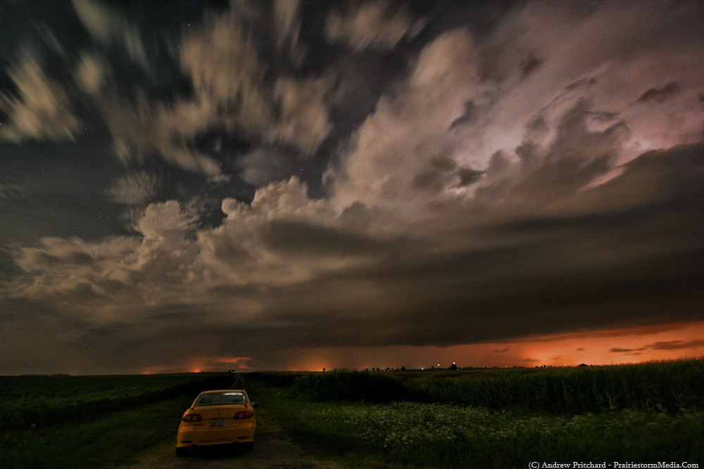
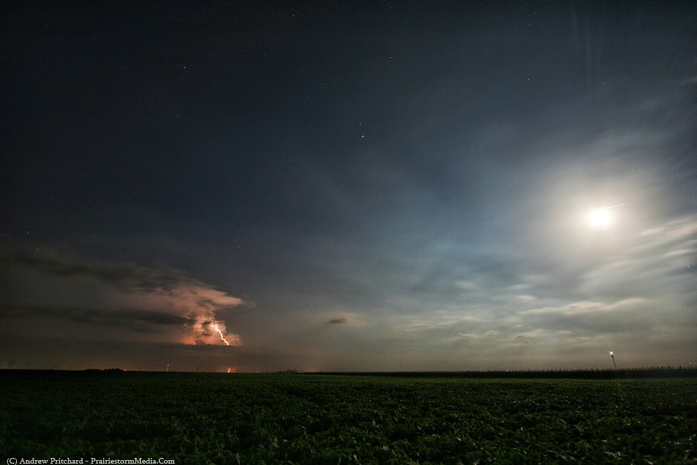
What a nice chase day. Targeted and executed well for once this year, as both tornadoes were within about 8-10 miles of my target of Janesville from 24 hours out, and I didn't have to drive more than an hour away from home. Met up with Scott Weberpal and Chris Gullikson in Janesville for dinner and then made my lightning illuminated way back to DeKalb.

Thursday, July 22, 2010

Updated chase forecast... 7/22

Still like a southern Wisconsin target for this evening for a supercell or two. Current target is still in line with yesterday afternoon's thinking - Janesville, WI.

Currently, a large area of rain and embedded thunderstorms is moving across the target area from southern Wisconsin and far northern Illinois stretching westward into northern Iowa with the bulk of the rain shield across Wisconsin. An MCV is currently located just south of the Minneapolis area in SE Minnesota, very evident on radar imagery at the moment. An outflow boundary trails across SW Wisconsin into northern Iowa along and south of the current convection. Satellite imagery shows dense cloud cover associated with the convection over all of Wisconsin and far northern Illinois into northern Iowa. At the surface, temperatures have already reached the mid-80s in Iowa and north central Illinois south of the convection where at least partially clear skies are evident, with lower 70s td's over spreading the entire warm sector.

Current thinking is that over time the trailing convection should begin to erode first over northeast Iowa, and eventually into southern Wisconsin and northern Illinois. Any clearing over the warm sector along and south of the boundary should allow for rapid destabilization, and lead to a very moist and buoyant lower level. Given minimal capping, a potentially strongly unstable air mass and sufficient convergence along the trailing outflow boundary, scattered severe storms should begin to develop by mid-afternoon over northeast Iowa and southwest Wisconsin. The best chances for storm rotation will be near the warm front/ofb just ahead of the surface wave in southern Wisconsin where winds may remain southerly, or even back slightly to the SE, likely near Interstate 39 from Madison to Rockford, but more specifically I think near the Janesville, WI area.

It remains to be seen how much destabilization will occur, and to the extent that surface winds veer in the wake of early morning convection over the target area. While a best case scenario suggests a window for tornadic activity across the southern tier of counties in Wisconsin, and perhaps far northern Illinois... should sufficient destabilization not occur and/or surface winds do veer significantly in the wake of the lead wave an e-w oriented linear mode of convection with gusting outflow boundaries killing off tornado hopes is a very possible outcome.

For now, I will remain in DeKalb closely monitoring satellite and surface trends. The target is not all that far away, so I have the advantage of letting things play out. However, if today is going to produce, it may do so at short notice so close attention to boundaries and any clearing will be required.

Wednesday, July 21, 2010

Thursday Potential N. IL and S. WI

Been trying to hold off on getting excited about this one, as these July days love to just vanish or fall into the mushy HP and MCS category, however this one has kept my interest, and actually increased in potential since I first noticed it. I would go as far as to say there is a fairly good chance at a couple tornado producing supercells in southern Wisconsin and northern Illinois tomorrow.

My current threat area for a few tornadoes is near Interstate 39, between Highways 20 in Illinois and 18 in Wisconsin, or an area from Rockford, IL to Madison, WI and about 50 miles west of that.

Should be a round or two of convection along the synoptic warm front across northern Illinois and eastern Iowa overnight and tomorrow morning, lifting north into Wisconsin eventually. South of this convection, at least partial clearing should allow for fairly rapid destabilization along and south of the warm front in northern Illinois, and eventually southern Wisconsin. A strong low level jet will increase out of the SSW and aid in eventual development of scattered severe thunderstorms ahead of the surface low and weak surface boundary in far northwest Illinois and southwest Wisconsin. Storms should move east across the area, in a highly sheared environment with 0-1 km helicity values approaching 250-300 m2/s2, especially near the warm front in southern Wisconsin. Given the strong directional shear, and should ample instability be realized in the warm sector tornadic supercells should be a decent threat. Hard to nail down a specific target at this point as the position of the surface boundaries could be greatly effected by overnight and early period convection, but an area just west of Janesville, WI looks to be a solid starting point.

I'll likely update again in the morning as things become more clear, and will hang in DeKalb for the better part of the morning as I'm not convinced northern IL won't see a significant threat and I would hate to get suckered too far north and miss something close to home. More than likely, where the warm front ends up is where you will find me.

Tuesday, July 20, 2010

New serving at Wrigley Field...

A heart attack in a helmet:


Spent last evening at the friendly confines to watch the Cubs get creamed by the Houston Astros. I figured after dominating the talented Phillies, we were due to get embarrassed by poor competition. Still, there aren't many better places to be on a summer evening than Wrigley!


Coming up, nothing overly interesting weather wise. Thursday has my attention, but it's showing a real tendency toward just being a real rain soaker event. I'll keep my eyes on it as the shear profiles along and near the warm front in northern Illinois, southern Wisconsin and northern Iowa bear watching. If the warm front ends up covered in convection, the point is moot.

Sunday, July 18, 2010

Today's Prize and Tomorrow's Crap Forecast

As expected, I was treated to an amazing display around the sunset hours tonight. I time lapsed a storm from towering cu to mature storm to post-sunset electrified updraft tower. The thing was surging and dying for over two hours, and I thought it was done for at sunset. However, in the twilight hour another updraft surged up and soon became absolutely electrified. The time lapse should be amazing, but I may save it for the DVD. This year's DVD, which again I was thinking about not making, will probably end up 60/40 for artsy fartsy time lapse type stuff to actual live chase footage. Scott Weberpal briefly mentioned in a conversation he and I quickly had this evening that there is no real appreciation for the creative side of storm chasing and weather observing anymore. I agreed, and added that it seems all anyone does to be a storm chaser is buy tons of data and a cheapo digital camera and take the quickest, most poorly composed images possible and upload them to their local forum or social networking site ASAP. If that's kosher for you, so be it. I grew up watching the beautiful structure / tornado video and time lapse masterpieces by those who started it all, and to that I try to stay true.

I don't chase for the money or the adrenaline. I don't chase for the publicity I may get on a forum or social site by uploading my crappy images before I even stop to pee after a chase or streaming the second I leave the front door. There are any number of reasons I don't chase, but there's only one real reason that I do chase, and that reason is the beautiful scenes that I am treated to day in and day out on the open road. I chase to be all alone in the middle of a soybean field being swarmed by mosquitoes as the sun disappears while a thunderstorm updraft tower erupts with lightning in front of me. Growing up I had a passion for tornadoes and thunderstorms, and I also had a passion for photography. I was a walking waste of film as a kid. Now that I'm living the dream as a storm chaser, my goal at the end of the day is not to score a live phoner with The Weather Channel, but to attempt to capture even half the beauty that stands in front of me every day that I spend in a thunderstorm's presence in one moment captured in time, be it a still photo, action packed video or a peaceful time lapse. While the aforementioned reasons or outcomes are all valid, it's not the dream I saw for myself as a tornado obsessed 3 year old, and it's not the dream I set out for today.

Wow, this is getting really lovey dovey towards mother nature. Point is... I really appreciate those that actually take half a second to compose a photograph or shoot well composed video. If that's not your cup of tea, and not why you chase, or how you choose to appreciate mother nature, that's awesome - but if you won't take half a second to capture the beauty in front of you, I won't take half a second to look your direction. Each year, that's what I try to get more and more in touch with when I produce my DVD. I have more tornado footage than 2009, but less than 2008, but think this could be the best weather DVD I'll produce yet and I've yet to really begin plotting it out.

Tomorrow's forecast looks bleak. Early morning storms will likely ruin the day for these parts. If things can hold off late enough in the day we'll talk. Monday looks decent, but I'll be spending the evening at Wrigley Field watching my loser Chicago Cubs play. Tuesday... well, we'll get to Tuesday another time.

A couple images from tonight:


Saturday, July 17, 2010

Turkey towers at sunset and upcoming ops.

Spent the evening on Thursday time lapsing turkey towers going up and evaporating across eastern Illinois. I'll mess around with the actual time lapse later, and will probably just save it as filler for the DVD this fall. I did take a few still photos, and figured I would throw those up here really quick, so you can check those out below. I went to an old favorite spot that David Bellmore and I used to go and sit in our very early chasing years before I actually had a drivers license. We'd see storms moving into the area and head out to this little spot a couple miles out of Urbana and watch things go nuts off in the distance. It all starts somewhere!

As for upcoming stuff, we do stand a chance at some thunderstorms in central Illinois today and tomorrow. I don't expect anything severe this evening, though at twilight with the more "dry" air in the area this evening some photogenic opportunities may lay ahead for those around the Interstate 72 corridor from Decatur to Danville, IL. A weak surface front is draped across the area with a meager wind shift line, accompanied by a again, weak upper level wave. However, with sufficient afternoon destabilization I expect this to be enough for a few storms to pop off in this area sometime around the dinner hour. Activity should diminish quickly around sunset, but may linger an hour or two long enough to get a couple twilight hour lightning photos if you're lucky enough to get a stronger cell in your area. I've got plans for a few hours this evening, but may try and sneak back out for some more time lapsing and sunset photography.

Sunday looks like the bigger severe potential day in central Illinois. Tornado potential is fairly low, but does exist. As per usual in the summer, early transition to a messy MCS is likely, so tornadoes will likely be few and be early. It remains to be seen how today and tonight's convection in Minnesota and Iowa will affect our play in Illinois tomorrow. One solution is an ongoing MCS that plows into central Illinois during the late morning, hopefully late enough to get some heating and enough juice here in eastern Illinois that re-intensification occurs and we get a decent bow echo out of the deal. Another solution shows things winding down overnight, leaving an MCV in western Illinois during the late morning. This would be the preferred solution as it would tend to lean more toward an isolated tornado potential early on in storm evolution.

As it stands, the best shot of severe weather Sunday afternoon will be generally east of Interstate 55 from the Chicago area to Springfield and then east into central and northern Indiana. Luckily, I'm home in Champaign right now for unrelated reasons, and should be in seemingly good position to let things materialize and come to me during the afternoon. Whether or not this means severe weather, or a convective wash out remains to be seen! I'll try to update again tonight or tomorrow morning once things become more clear, as hashing out details such as location, timing and storm mode are all near impossible at this point.


Tuesday, July 13, 2010

Non-Chasing Forecast for 7/14

The terrain is going to be a big bummer on this one, and the vast differences on main operational models are also a bit troubling. Anything south of the MN/IA border should be linear pretty quickly. Given extreme instability and unseasonably strong flow, a tornado can't be ruled out in Iowa, but I think it would be a fairly isolated and embedded event given more veered flow in this area.

While it's a fairly wide target, I do see a region that does stand a chance at a localized tornado event tomorrow assuming the NAM and WRF are correct. My somewhat large target box would be along a Minneapolis to Rochester line, and then east to a Tomah to Eau Claire WI line. Chasing that area of Wisconsin will be a real treat, so one's best hope is probably to try and get something early before things get into the god awful terrain near the Mississippi river in far eastern Minnesota. I think anything significant should be along and north of Interstate 90.

Eventually training/congealing will likely lead to congealment into an MCS. If I didn't have plans here in northern IL til mid-afternoon I would probably venture out to far SE Minnesota (Faribault, MN - if I had to pick a target city) just to get in a nice July chase, but this will probably save me some frustration. I just think the terrain on this one will be a bigger day ruiner than the actual setup itself.

Now if you're siding with the GFS, tomorrow looks like an absolute wash. No surface flow, and completely unidirectional flow above that. With all that instability and no real directional or speed shear, you'll end up with a big multi-cell cluster that does a whole lot of gusting out. I think the NAM solution is a little more likely, but it's something to keep in mind tomorrow.

I guess I'll just hope that something inexplicably fires in southern WI or NW Illinois that I can play with. Don't count on that one though. My best bet is lightning after dark this far east.

Sunday, July 11, 2010

Marginal Potential 7/11

Scott Weberpal shot me a text this evening, and after taking a brief glance I tend to concur with the idea of a marginal shot at an isolated tornado or two tomorrow, generally across eastern Iowa into northwest Illinois and maybe even far southern Wisconsin tomorrow evening.

A fairly robust shortwave is currently making it's way thru the northern plains overnight, with several convective complexes moving across Minnesota and Iowa associated with the wave. Some of this convection will likely be ongoing thru the morning hours across portions of central Iowa and northern Missouri. In the early morning hours, the shortwave and a potential MCV which if presence could warrant a heightened severe potential across the mid-Mississippi Valley region should be located over central Iowa. There is considerable disagreement among the operational models to the location and track of the shortwave, but a movement into eastern Iowa early and into northwest Illinois by peak heating seems reasonable to me. Convection should continue and likely die out during the late morning and early afternoon across Iowa southward into Missouri. Re-intensification of the tail end of this complex into a forward propagating MCS across southern Missouri during the afternoon is possible, which could pose a severe wind threat into the evening as it moves east south east into southern Illinois into the night time hours.

Further north, as convection begins to decay and destabilization occurs ahead of the wave and potential MCV in far eastern Iowa into northern Illinois, new convention should begin to develop toward late afternoon. While directional shear will pose favorable turning, speed shear may not be all that impressive which may favor either a multi-cell pulse severe threat or brief HP supercell mode, the presence of an MCV and slightly stronger than forecast deep layer speed shear could present a brief window for isolated tornado development with any stronger cells that manage to develop ahead of the wave, likely in northwest Illinois. Good lapse rates, and good low level turning could be enough to squeeze out a surprise.

This is certainly a very conditional, and best case scenario only presents a marginal tornado risk, but for mid-July still certainly warrants a mention and half an eye tomorrow afternoon. Tia and I are celebrating an anniversary tomorrow, but being the broke college students we are, have no major set-in-stone plans beyond spending the day together in some fashion. Being the sport she is, she has already given the green light to the potential for a local chase should things fall into place. That said, I'm not interested in wasting a potential relaxation day to sit and do nothing only to spend hours in the car for no reason, but it's been a while and should stuff go locally we may venture out for a looksie.

Best time frame and region for any "violently" rotating columns of air to make their way toward ground level would be right around peak heating from 3-6 PM in an area from Galesburg to Sterling, Illinois. I'll enter a disclaimer however that with such model disparity on the outcome of such a complex convective scenario that this target area is subject to change, or completely disappear by tomorrow morning.

Tuesday, July 6, 2010

Fireworks and poser kittens.

Back in Illinois now after an excellent 4th of July holiday. As is tradition, my family spend the weekend at our lake house in central Wisconsin. I couldn't get enough of the lake this weekend, as this time of the year is about as perfect as it gets for that place. If you've never swam in a natural spring fed lake, you're missing out big time. My uncle described it perfectly this weekend as swimming in "liquid silk", and I couldn't agree more.

We did the typical small town fireworks display in Oxford, a tiny town of 400 that has Chicago style traffic jams following the display. They do it up right, and people have begun taking notice and flock from all over the area to pack into that small centrally located park for the display on Saturday night.

The weather couldn't have been better, aside from the drizzle experienced on Monday. Friday and Saturday one had a heck of a time trying to find a single cloud anywhere in the mid-west. Sunday was patchy, with some awesome downpours that I was lucky enough to experience while swimming in the middle of the lake. Going along with swimming in a natural spring fed lake, if one has never swam in the middle of a lake in a torrential down pour, you're also missing out. It's an experience hard to describe.

Then, there were the new kittens that a stray had given birth to at the ranch across the street. One of the kittens took quite a liking to my family and began whoring it up each day. She or he decided to go for a posing session for me and was really milking it in front of the camera.

I felt like I had more to update when driving home last night, but am short on words at the moment. Nothing interesting weather wise recently, or in the near future. Just had a brief downpour with the sun shining here in DeKalb as one of the puffy cumulus clouds in the area decided to burst. I'd love nothing more than to get a twilight or night display from a little pulse thunderstorm but have zero hopes in that happening, though the chance is there this week. Nothing severe at all forecasted, but perhaps a decent photogenic treat will be thrown my way.

Until then, here are a few fireworks photos along with a few shots of the kittens from the weekend in Wisconsin.

If I'm not standing under a mesocyclone, this is the one place in the world I wish I was every day:


Each time I go, I plan on spending more time on star trails, but once nightfall arrives I'm so burnt out from the days activities that I can't bring myself to get out there. The above shot was taken the night I arrived back to the lake after the Bowdle, SD chase.

I really liked this one simply because it shows the involved danger with attending small town fireworks displays. Don't want to be under those falling embers hitting the ground! :) It's a definite experience to be under the "fall out" and seeing sparkly colors falling right on top of you.


Tia getting the kitten all riled up with the ole "fast random moving stick" game.


Kitty insists that if my brother just let her use his camera briefly she could get some slammin' shots.
It's not even 5 PM!