
I haven't updated for a while, but there has been nothing really worth mentioning. People are gungho again for this weekend, and like always I'm the pissy nay-sayer, but again I just do not see it. March 8th has ruined people. Now every single low pressure system that crosses the continental US will produce tornadoes and must be chased! Chasers from all over will be getting a sun tan in various locations of the central plains tomorrow. If you live in the area and are going to keep an eye on things, that would be one thing, but I really can not fathom long distancing this one or even really canceling plans if I -did- live in the area. Shallow moisture and an outrageous cap will keep things quiet until after dark, when elevated storms may develop along the retreating dryline when it intersects the cold front, likely across central Nebraska and Kansas. Congratulations, you just drove 500 miles for a night time lightning display which will be a dime a dozen in a couple months. I suppose when I see my facebook newsfeed light up with cell phone photos and reports of a large supercell breaking the cap you are all free to track me down and force me to eat my crow. Or perhaps I'm not a true chaser? Because as I stated, chasing every single low pressure system with dew points over 30F is what quantifies being a dedicated chaser. Meanwhile, my guess is that a few chasers who will have that massive supercell all to themselves tomorrow evening because they are the truly dedicated souls, will not leave their homes during the first legit event that strikes two states away from their door steps. My how the dedication will quickly disappear. Wow. That's getting way off pace.
Anyway. I had nothing to write but figured I would just open up a blank entry and see where I got for the sake of updating and sure opened a can of worms on that one. Friday looks like a waste as well. Again, a waste for someone who is planning on making a long trek. I'm sure someone somewhere will find a dust poof under a shelf cloud on the linear complex of storms to prove me wrong. I don't blame those in the TX/OK area for keeping an eye on things, but I'm willing to bet it ends up as a linear event in Missouri and northern Arkansas. We will likely get to experience some thunder early on Saturday morning here in Illinois, but my attention is largely on next week. I realize last year largely sucked, and this has been a slow starting year but you've got to be patient. Just because the pattern has been BS, doesn't mean you need to chase BS. A slow pattern doesn't make a meager setup any less meager and I fail to see how a 1200 round trip with a disappointed drive home is going to make it an easier on your mental well being. I honestly can't even see how this can be a slow year already when we have only just begun to get into the season. It's like your favorite baseball team starting the season by losing their first two games and writing the season off. The numbers are down this year, that I do not doubt. But where are those February and early March tornadoes traditionally found? In the southeast and gulf states. Especially in an El Nino year such as this. Are you telling me that you are really missing out on those tornadoes that you would have otherwise seen in Georgia and Alabama in a more active early season? No.
My attention right now is on early next week. Tuesday to be more specific. The GFS is gungho about Monday the 5th, but I do not buy that for a second right now. Each model run is all over the place, but for another reason added to the list that I do not understand about some chasers right now, people are eating it up. The thing has lied and lied, and shown a consistent bias on being too fast, yet a week out people are taking off work for Monday when all other signs and some reasoning right now show Tuesday the 6th to be the more promising day. The scenario that my eyes and gut see playing out right now, is a more traditional "day before the day" potential in the western plains on Monday with possibly a supercell or two, but not the display that will likely follow the next day. A couple good storms could be in store for local chasers, or those who want to be out a day early, though I think the two targets will be some distance apart on the two days. It has been my feeling for the last day or two that the Iowa area, or areas very near there could be in store for a classic tornado day on Tuesday April 6th. The GFS does not know what to do with that energy; how to eject it, where to kink it, etc. The euro, among other models has been slower and deeper ejecting the system late on Monday and really digging it in on Tuesday likely setting up a prime region in Iowa and Missouri. That's even fairly specific for this far out, but this is the general location and time frame I would be concerned about. Again, I'm sure my gut is lying to me, and some lone supercell will go tornado crazy on Monday, but again, I'm resting all my cards on Tuesday. How the system evolves after that will effect whether or not any subsequent tornado days lie ahead.
For now, I think any reasonable forecaster has to almost completely cast aside the GFS due to it's inconsistencies and proven fast bias at this time frame. I'll continue using a mix of the ecmwf and a couple other models, climatology, and gut feelings in watching what in my opinion could be a very good start to the 2010 chase season for many on Tuesday.
Wednesday, March 31, 2010
Friday, March 19, 2010
Well. That was an adventure.
It was sunny, 65 degrees and I had the evening free so where else would I have gone?

I also accidentally caught a passover of the International Space Station.

The adventure starts shortly after the above two shots. My car had been off the entire time I was walking around that flooded road, which was actually very peaceful with the only noise being the wind blowing through the nearby turbines, and toads croaking in the flood waters. This is probably the most desolate area you can find in DeKalb County. The road is barely wide enough for my car to fit on, so even though I've never seen another car on the road before, I don't even know what we would do if one did come. I was playing around with photos of my car in the twilight, and wanted to turn it around quickly for one last shot. So I three point turn my car, and get back out with it running to snap one or two more photos. I realize the fan is running pretty hard, so I think "oh? I must have hit the A/C or defogger button or something." Got in the car... no, that's not it. That's when my attention hits the temperature gauge and realize it's spiking. This is terrific news! I could not be in a more rural area. I quickly decide that if I'm going to have a major problem I need to get to a slightly bigger road. I quickly began driving back up this winding dirt road until I "upgrade" to gravel and approach a couple farm houses, but now my temperature gauge is getting up there so I quickly shut off my car. I was kind of wary of going up to one of the farmhouses at this hour because 1) I'm guessing they'd be weirded out and not answer anyway at someone knocking on their door in that rural an area at this hour and 2) ... I think I actually just covered everything in #1. Anyway, I put my four way flashers on in the case that someone looked out their window. A few farm dogs got pissed and began barking at my car from a distance. Even more reason I was not approaching the houses right now.
Eventually low and behold, headlights appear. The car eventually approaches, and turns out it's one of the farmers that lives in the farmhouse with the pissed off dogs. He had some coolant in his trunk that he let me use to top off my tank which appeared low. We sat and watched it run for a while, and my temp remained around a moderate level. I offered to pay him for the gallon of coolant I used, but he refused saying that he had been helped many time on the side of the road so he was just passing it along. He gave me his cell phone number just in case, and I was on my way. Half a mile later I'm spiking again. It's either 1) nurse it home very slowly or 2) call a tow. I opted to try my luck at number one. This ended up working, though it took me 4 hours to make an approximately 7 mile drive. I drove in little spurts and when the temperature began to rise I would quickly pull off and let it cool back down. I eventually made it from the dirt road, to gravel, to pavement, to two lane highway and then to the outskirts of town. The repair shop was on my way home, so I just dropped the car off in their lot and left the keys in the drop box and walked the rest of the way home.
I literally gave myself nightmares of the mechanic calling me informing me that my car's engine was toast, or that I'd blown a gasket or some other repair over a grand to have done. The guy woke me up this morning with mixed news. The good kind of mixed news. The good news is that it's a relatively cheap and easy repair. The bad news, there is only one of the parts I need available in the entire US. So, they're having it sent quickly, but my car is likely sidelined until Tuesday, Monday if I'm lucky and Wednesday if I'm not. Additional good news is that the weather should be crappy all weekend so my car is not really needed. Adding to that, Tia begins her spring break this afternoon and was planning on coming up and spending most of the break with me so I won't be without wheels if they become needed. I suppose it's a good thing that this storm system moving through is supposed to lack the fire power for any significant weather. I'm ignoring the potential for snow accumulations at this point. On the bright side I suppose, late March snow does not usually stick around long. If we do *shudder* pick up a few inches, it should be melted within days as the high March sun does it's work and we hit 50's again in a couple days following the cold front.
Oh, for those interested the problem was a belt/pulley system powering the water pump. There were no noticeable leaks, but this system was "disintegrated" in his words. This in turn does not circulate the coolant through the system so it just sits in the radiator and gets hotter and hotter before evaporating. Thus, I lose coolant without actually having a leak. Better now than under the meso. I can't even imagine that. Having your car overheating to the point you can only drive half a mile before it spikes with a tornado approaching you. I guess at that point it would be faster to literally run for your life.
Anyway, one more photo. I'm not overly happy with any of the photos that I shot. Was hoping they'd make the trip worth it but none really stuck out to me. I did shoot a time lapse of the sun setting in the wind farm, so hopefully that will turn out when I fudge with it later.
At least the scenery was nice. But really, why is it that my only car issues happen about as far from civilization as I get during the trip. This one rivaled the trip last June having to nurse my car home at 40 mph on a spare tire from southeast Iowa. A trip that normally takes 2.5 took 5 hours. I suppose actually this one blows that one out of the water... this 7 minute drive should have taken me 15 minutes tops. 15 minutes that turned into 4 hours. Ah well, the repair bill on this will be less than the $600 Iowa gave me that day, and I don't plan to total this car a week after that repair bill. *knocking on every piece of wood in the state of Illinois*

Monday, March 15, 2010
March 11 2010
You've already seen the images and know the jist of the story, and it's not as interesting as those Oklahoma tornadoes from the days before. That said, I've completed a full write up with some weather data and photographs from the intercept of the low topped storm north of Urbana from this past Thursday. I'll paste the text below, but if you're interested you can view the actual page here:
http://prairiestormmedia.com/20100311.html
Early on Thursday the 11th looked like a big minisupercell day across Illinois and Iowa. However, as the day drew nearer things did not look as favorable. A warm layer at H7 was killing off much hope of deep convection, and surface winds were slowly veering and weakening across the target area. These things do not add up to a very favorable March severe weather setup. I already had the day clear of plans for a potential chase and was visiting home for spring break and was already in decent position, so I continued to monitor things at home in Champaign. Morning water vapor imagery showed the cyclone centered over Iowa, with morning thunderstorms retreating north into Wisconsin, Indiana, and Kentucky. The mid level dry punch had worked it's way into Illinois and Iowa and was allowing for insolation, but at the same time rapidly mixing out low level moisture from west to east across the state. Surface data from 3 PM showed moisture rapidly mixing out in western Illinois with dew points now in the low 40s, with surface winds beginning to veer out of the southwest. Eastern Illinois held on to mid 50's dew points however, and surface convergence was forecast to increase towards sunset so I kept my eye on the satellite. Sure enough, around 5 PM surface winds really began to converge right around my location in eastern Illinois. Satellite imagery began showing an area of agitated cumulus along the Piatt / Champaign County borders, with storms beginning to initiate further north towards Kankakee. A few returns began showing up in my area of interest just west of Champaign. I watched from the front yard as one area really began taking off. After a long winter this alone was enough to get me in the car for a short drive. Tia decided she was up for a quick outing and hopped in the car, and we were off.
This area actually began to organize fairly quickly, and by the time I had headed north out of town on Route 45 a fairly substantial low topped storm was underway just north of Urbana. Storm motions were very slow for this time of year, so I was able to easily keep ahead of it by stair stepping northeast along the county roads in northern Champaign County. Unfortunately, things got off to a late start on this one so our time together was limited before the sun began to set behind the pretty storm. The core actually strengthened healthily and produced pea sized hail which covered the ground in Thomasboro. Staccato lightning bolts also accompanied the storm at sunset, which was quite a treat to sit back and take in. March storm chasing is often -very- frustrating with low visibilities and fast storm motions, but this one was neither! A beautiful updraft tower and rain free base with storm motions that could not have been over 20 mph. That being in my home stomping grounds of extremely flat Champaign County and familiar roads were the icing on the cake in this first convective outing of 2010. Once the sun faded, I headed back towards town. Not before catching a glimpse of the storm in the twilight in the distance and having to stop once more for a couple photos. Tia and I were hungry as it neared dinner time, so we detoured to Chili's for a dinner where we played a role reversal as she devoured a massive burger, and I played it safe with a tasty pasta.
I wish the minisupercell outbreak had materialized, but short of that I can't think of a better way to start to the 2010 warm season. After the year of stress 2009 was, let's hope this is a good omen.
Thursday, March 11, 2010
Low topped storm at sunset
The day obviously didn't play out as many had hoped in the region, but I kept my eye on the boundary along I-57 in eastern Illinois, especially as convergence increased along it toward sunset (but unfortunately as many other ingredients trailed off). Eventually we were finally to get initiation in the area, so I went out to take a peak at a cell that was forming to the west of Champaign. It actually turned out to be a photogenic little cell and tripping a couple severe level hail indicators on radar. It was accompanied by staccato lightning strikes until I left it after sun down.
Not a tornado day like we'd hoped, but after a long winter this was a nice treat.


Not a tornado day like we'd hoped, but after a long winter this was a nice treat.


Dwindling Minisupercell Potential
Still not overly impressed, but there is time for improvement and being a local day I have all the time in the world (or until sunet, whichever ends first) to sit and wait for that improvement to occur. If I had to pick a target today, it would be somewhere near Mattoon, IL. That's about 40 miles south of me here in Champaign so I'm content sitting on my butt until things become clear.
Warm air is still killing off instability, with a nice thick warm layer at H7. In addition to that, hodographs are as good as they're going to get right at this very moment. I'm only concerned about the lower levels, but even that bottom portion is not all that impressive. Areas near I-57 still have decent turning, but really lack on the velocity end towards afternoon. Both of these factors don't leave much room for hope. The RUC is especially negative in keeping warmer H5 temperatures than the NAM, but seems to be falling more in line with the NAM on subsequent runs allowing for slightly better low level cape values. It's probably about time to be done looking at the models though, and just start hoping and praying and wishing or what have you that the inversion at 700 mb slacks and the low level wind fields do not. If we can get a little help, I could still see a minisupercell or two forming near Interstate 57 from Champaign to Effingham. My hopes are not all that high right now, and I'm only giving it this much attention for the lack of effort it will take on my end to intercept if things do turn for the better. This isn't the best stomping grounds as things can get hilly once you get closer to the Wabash River, but it is what it is.

That would get it done if we're talking low topped supercells, but this is assuming less screwy H7 temperatures as well which remains to be seen.
Wednesday, March 10, 2010
1 in a million. So you're tellin' me there's a chance?
Looks like a marginal tornado threat in Illinois and Iowa tomorrow afternoon, but with the day completely free it's big enough for me to ponder that lovely first chase of the year. Last year I was really gungho on a cold core setup in eastern Iowa, but today I've reverted back to the low topped supercell potential in central Illinois. I'd obviously rather avoid Iowa, but the cold core potential was very intriguing on last night's run. Not so much today. Stressing over the models at this point will be pointless though, as it will be a wake up and see type of day. You know, I'm playing with the models now though and it doesn't look entirely unlike a cold core potential in NW and parts of central Illinois right now.
Anyway. I'll make things brief right now and do a better analysis later tonight and tomorrow morning when things are more certain. As of now, I'm still keeping an eye on eastern or southeastern Iowa, but my attention has really drifted from this area. For now, I'm watching somewhere along a line from Galesburg to Peoria to Springfield, IL. LI's will be peaking nicely around -5c or so in this area with very steep lapse rates thanks in part to the very cold upper level temperatures associated with the cold core of the H5 low. The vort max should be located along the Missouri and Iowa border by mid afternoon while a wave kicks out along the surface boundary in SE Iowa and W Illinois. Convection should begin early, initially in southern Iowa, and then arcing down towards western Illinois by early afternoon. In a day like this, being at your target location by noon would not hurt. Should surface heating occur, low level instability should rapidly increase, and good directional shear in the lower levels would allow for storm rotation. Clearing in eastern Iowa and northwest Illinois would be very pertinent to that situation. Ample surface heating would allow for rapid low level stretching of updrafts under the cold upper low which could aid in cold core tornado production.
These thoughts are likely all over the place. To sum up, I'm looking at two areas. The first, the most conditional of the two is southeast Iowa very early in the day. The second more likely target is going to be somewhere in central Illinois by around 2 PM near Interstate 72. I don't for see a big tornado event, but a lot of clear skies could convince me otherwise. You know, Galesburg to Peoria really has my attention. I'll stop now.
Friday, March 5, 2010
Same stuff, different night and a rare negative write up on this upcoming wx week.
Another night spent outdoors. I think this may have been one of my favorite. I don't know. I didn't really do anything early enough to play with twilight which is my favorite time to be shooting, but I managed to get some decent lighting effects with the city tonight. I had midterms all this week and a couple bigger assignments due, so I didn't get a lot of sleep last night. All went very well however, and I managed to get in a major nap this afternoon. I woke up around sunset and was itching to get out there. I'm heading back to Champaign for the week tomorrow afternoon for our very early spring break, so I cleaned some stuff out of the fridge for a quick dinner to empty it out and was on my way.
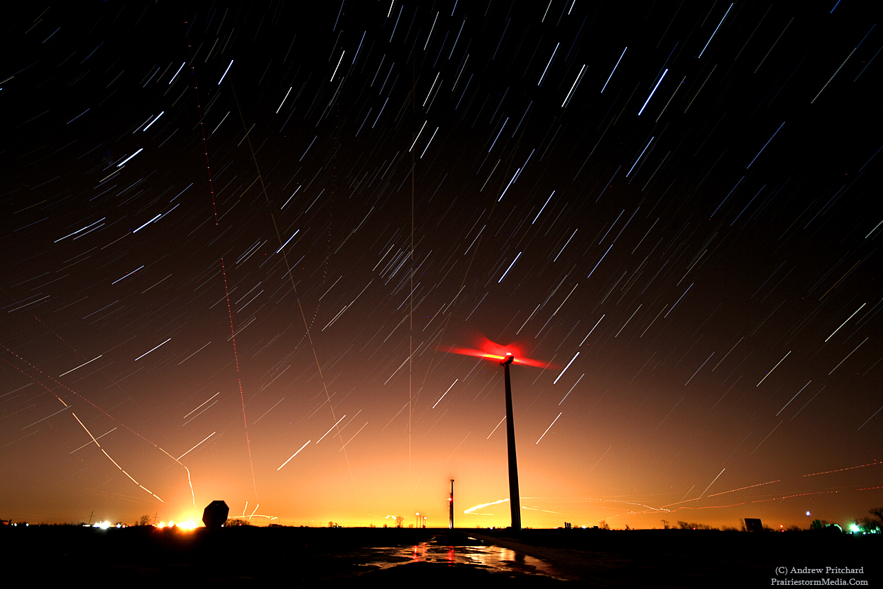
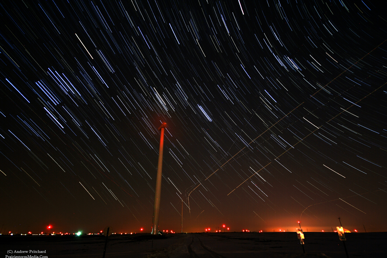
I more or less had an idea of what I wanted to accomplish, and didn't really drive far. I went back to my favorite place and parked right in the middle of the DeKalb County wind farm. I managed to find a really nice gravel road that has two of the massive turbines right next to the road on either side so I can get up and close without actually trespassing and giving anyone any reason to stop me. I did almost have a semi-run in at one point. I was finishing up a longer star trail session and headlights appeared behind me down the service vehicles only road coming toward me. I was done at this point, and his high beams would blow out any images coming up anyway so I just packed it up and got in my car and quickly took off. Of course, I wasn't doing anything illegal, but I just figure if possible I'll just eliminate any even small potential for unnecessary trouble. Anyway, once I started driving they turned around and went back the other way, two turbines away. They were closer than I realized! High beams will do that I suppose.
Ah well. Not a lot of writing necessary for these images. After the last two outings they're pretty well self-explanatory. The air traffic around here is actually starting to get really annoying. One or two planes crossing the path is fine I suppose, but when it's one after another it really starts to become a distraction from the star trails in the image. I decided to use it to my advantage in the first shot, however.


I haven't written anything meteorology related in quite some time, but that's because there is nothing to write about. Some are getting excited about a storm system late this weekend in the southern plains but I just don't see it. Perhaps if I lived in Oklahoma or Texas I'd keep a bigger eye on it, but I don't. It does hold the potential for some thunderstorms, and perhaps a couple hailers but I'd be hard pressed to believe there will be tornadoes anytime this weekend. I really hope for the sanity of a few chasers out there that I am proven wrong, but I think people are really going to have to be patient this year. El Nino is still in effect, so the constant southward trend with storm systems is not a fluke with this weekends storm. I usually try and be optimistic for a gear tester or two in March, but I don't know that this will happen before April this year. I do feel April could be a big month in 2010, but that's three weeks away. For now, I think I'll be spending a lot more nights at the wind farm than I will worrying about a potential storm chase.
I more or less had an idea of what I wanted to accomplish, and didn't really drive far. I went back to my favorite place and parked right in the middle of the DeKalb County wind farm. I managed to find a really nice gravel road that has two of the massive turbines right next to the road on either side so I can get up and close without actually trespassing and giving anyone any reason to stop me. I did almost have a semi-run in at one point. I was finishing up a longer star trail session and headlights appeared behind me down the service vehicles only road coming toward me. I was done at this point, and his high beams would blow out any images coming up anyway so I just packed it up and got in my car and quickly took off. Of course, I wasn't doing anything illegal, but I just figure if possible I'll just eliminate any even small potential for unnecessary trouble. Anyway, once I started driving they turned around and went back the other way, two turbines away. They were closer than I realized! High beams will do that I suppose.
Ah well. Not a lot of writing necessary for these images. After the last two outings they're pretty well self-explanatory. The air traffic around here is actually starting to get really annoying. One or two planes crossing the path is fine I suppose, but when it's one after another it really starts to become a distraction from the star trails in the image. I decided to use it to my advantage in the first shot, however.
This is facing the city of Chicago, which is giving off the light pollution creating the actually pretty cool lighting. In DeKalb here I'm about 50 miles due west of downtown Chicago, but the suburbs are only a 25-30 mile drive so the "glow" from the city is pretty obvious in the open here. Also worth noting as I said is the incredible air traffic coming from the city. At any given time there are probably 20 planes all around my flashing around. Cool, but sometimes very annoying when doing these shots. I was alright with this case as I was wanting to show it all originating from the city to the east.
This time, looking west. This is where the air traffic gets annoying. I don't know. Perhaps no one else will notice or be bothered by it. I just feel like when doing star trails there are enough white lines going across the image, and I'd prefer they all be uniform without these other random chaotic paths throwing it off.
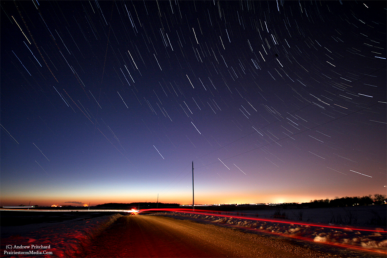
I had visualized this image all week and was really wanting to give it a try. It didn't turn out quite as I wanted, but I'm still pleased I suppose. As pleased as I'll ever get with my own stuff. I might try and work on it more later on, or might just leave it at that. I'd like to get more sky somehow, and less dash. But, you can't get as much sky as you'd think you could when you're trying to include the dash lights too. The windshield looks pretty big until you try doing something like this and it quickly shrinks up. Oh yeah, and go away airplanes. I think that might be the single most annoying thing to me about this image. Again, perhaps some of you four readers might actually think it adds to the photo, who knows. Not like I can tell him to divert his path, and trying again later won't work because there are 50 more waiting to come right after him. Ah well! I'm honestly just itching to get up to the lake in Wisconsin to mess with this more. The optics are better up there, and the terrain lends itself to far far better foregrounds in photos. Really stretching here. Hmm, flat bare field, or flat bare field with a tree next to it. That's why I'm always going back to the wind farm. It's the closest thing to terrain I can find around here. Storm chasing and night photography are like inverses when it comes to terrain I guess. I'll pull my face off trying to find a flat field while chasing a supercell thunderstorm, but when I'm out at night it's like, can I buy a freaking hill or two?

I haven't written anything meteorology related in quite some time, but that's because there is nothing to write about. Some are getting excited about a storm system late this weekend in the southern plains but I just don't see it. Perhaps if I lived in Oklahoma or Texas I'd keep a bigger eye on it, but I don't. It does hold the potential for some thunderstorms, and perhaps a couple hailers but I'd be hard pressed to believe there will be tornadoes anytime this weekend. I really hope for the sanity of a few chasers out there that I am proven wrong, but I think people are really going to have to be patient this year. El Nino is still in effect, so the constant southward trend with storm systems is not a fluke with this weekends storm. I usually try and be optimistic for a gear tester or two in March, but I don't know that this will happen before April this year. I do feel April could be a big month in 2010, but that's three weeks away. For now, I think I'll be spending a lot more nights at the wind farm than I will worrying about a potential storm chase.
Tuesday, March 2, 2010
More spending time outdoors at night
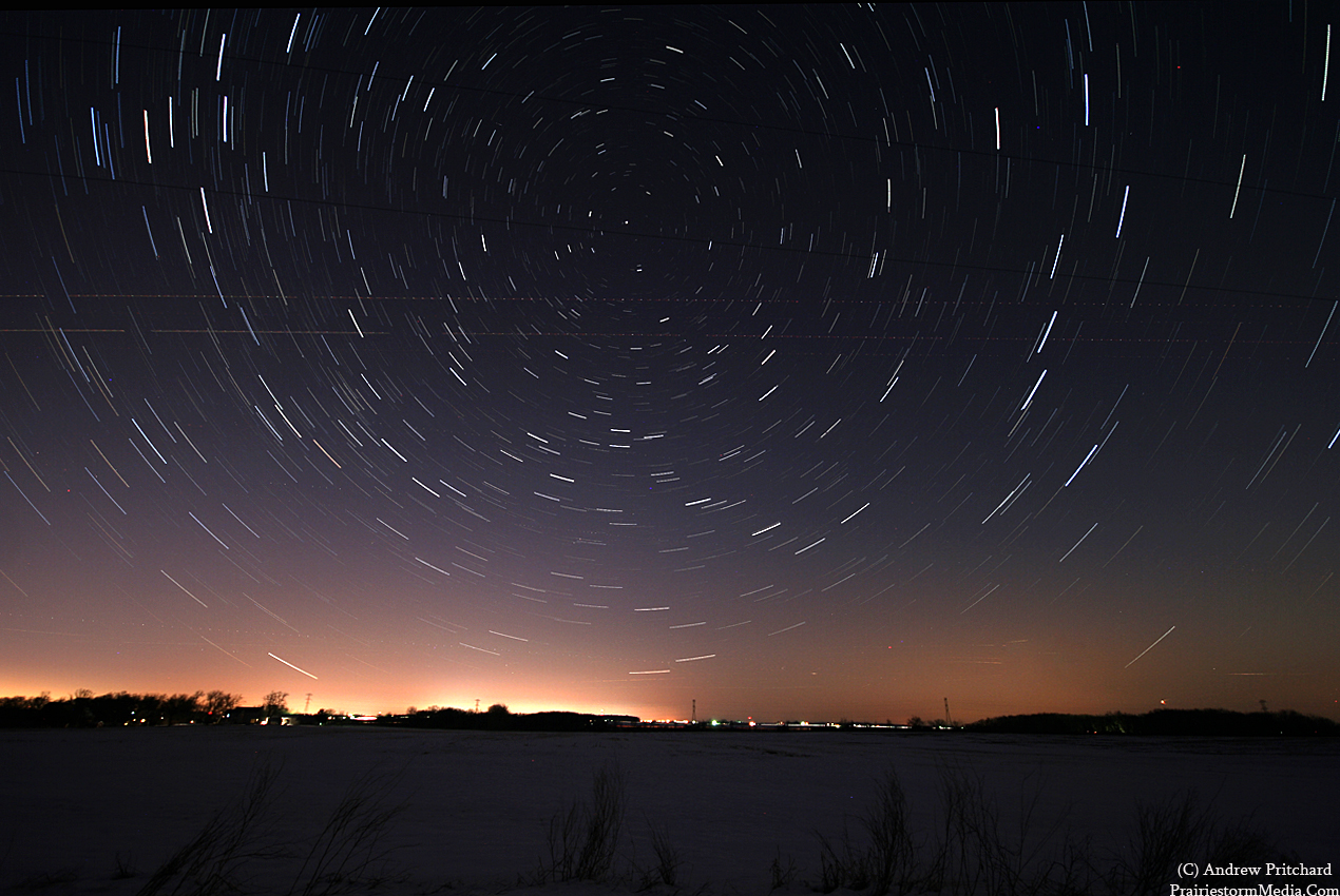
The day and night were forecast to be mostly cloudy, but surprisingly things cleared out by around 4 PM and left a big open blue sky that I knew looking out the window that I needed to go play with. After a long dreary winter, that will happen I suppose. I had no idea where to go. This terrain is terrific in the spring and summer when I'm trying to document thunderstorms, but when I'm trying to do simply landscape stuff it really sucks when you can't buy a hill or a grove of trees, you know? I have been having a south bias for whatever reason in exploring my new playground in the DeKalb / Lee County area up here. Back in central Illinois I'd simply know like the back of my own hand where to go for whatever type of foreground I seek. Up here, being a new kid on the block it's not to easy. So, even though I had more star trail photography in mind I made sure to leave early so I could do some exploring with daylight before I settled on a spot. I chose to head north since I have actually yet to do that on the back roads here. I ended up somewhere north of Highway 72, just outside the town of Kingston. I stumbled upon an area of rolling hills that suited my needs. I was hoping for more trees, but the rolling hills left me with a view of Rockford and Belvidere . Thank you Google Maps... I just went and used the terrain option and located the road I was sitting on. Looks like I was stopped on Snake Road, just north of Cherry Valley Road. Anyway.
I set up shop and played around some more with some star trails. All went smoothly, but I did have one interesting encounter. I never really consider the fact, storm chasing or just on a photo run, that I'm standing alone in the middle of nowhere, but at times things can make you realize that fact. I was listening to a pack of coyotes chirping in the distance, or whatever you'd like to call the ruckus they create, stirring up the local farm dogs. This wasn't really anything new, and was not an issue. However, about 5 minutes later I saw something about dog size hauling ass across the open field. The moon had barely risen, so it was still very dark, but light enough with surrounding ambient light that I could see the object running, pausing, running some more. Of course, in the middle of running a long exposure on the stars. I'm just thinking, whatever you are, continue on your merry way and please don't come over to investigate my situation. I made some noise in the snow and it took off the opposite direction as I expected. Just was hoping it wasn't the opposite reaction! You know how dogs can be sometimes, especially farm dogs when someone they don't know is in the area. They love to come sprinting at you to greet you, usually happily, but other times not. I don't exactly need a coyote or two sprinting in my direction for an unknown reason. Again, anyway. The photos:
This was the first exposure I did, starting about 45 minutes after the sun had set allowing for some twilight to get involved in the photo. Only two cars passed me on this road, and they both did so during this image. One guy stopped to make sure I was okay, and not having car troubles but once he saw my camera out he knew I was fine. I thanked him for checking anyway. Sucks when you DO have an issue and people just pass by.

This one is looking north towards Rockford, which is lighting up the horizon. The two streaks in the middle of the image are actually airplanes. The air traffic here was nuts. I guess that's what happens when you're south of a major city, and west or one of the busiest airports in the world. Sometimes a passing plane can add to an image, but the frequency, and common paths were starting to get annoying. You can actually see it more on the top image, on the left side. Planes were constantly appearing on the easting horizon from Chicago and flying right over my head.

This was going to be a stack of me doing various different poses around my car. I already botched that one by standing too far to the left. I was supposed to be reading a map. Ah well. It works enough for me to upload a copy I suppose. After an already long day of exams and classes, and now standing outside for a couple hours in the cold I was pretty ready for some food, so I cut things short. Once things warm up a little bit, but the air is still dry enough for good optics I'll hit it a little harder I suppose.

I set up shop and played around some more with some star trails. All went smoothly, but I did have one interesting encounter. I never really consider the fact, storm chasing or just on a photo run, that I'm standing alone in the middle of nowhere, but at times things can make you realize that fact. I was listening to a pack of coyotes chirping in the distance, or whatever you'd like to call the ruckus they create, stirring up the local farm dogs. This wasn't really anything new, and was not an issue. However, about 5 minutes later I saw something about dog size hauling ass across the open field. The moon had barely risen, so it was still very dark, but light enough with surrounding ambient light that I could see the object running, pausing, running some more. Of course, in the middle of running a long exposure on the stars. I'm just thinking, whatever you are, continue on your merry way and please don't come over to investigate my situation. I made some noise in the snow and it took off the opposite direction as I expected. Just was hoping it wasn't the opposite reaction! You know how dogs can be sometimes, especially farm dogs when someone they don't know is in the area. They love to come sprinting at you to greet you, usually happily, but other times not. I don't exactly need a coyote or two sprinting in my direction for an unknown reason. Again, anyway. The photos:
This was the first exposure I did, starting about 45 minutes after the sun had set allowing for some twilight to get involved in the photo. Only two cars passed me on this road, and they both did so during this image. One guy stopped to make sure I was okay, and not having car troubles but once he saw my camera out he knew I was fine. I thanked him for checking anyway. Sucks when you DO have an issue and people just pass by.
This one is looking north towards Rockford, which is lighting up the horizon. The two streaks in the middle of the image are actually airplanes. The air traffic here was nuts. I guess that's what happens when you're south of a major city, and west or one of the busiest airports in the world. Sometimes a passing plane can add to an image, but the frequency, and common paths were starting to get annoying. You can actually see it more on the top image, on the left side. Planes were constantly appearing on the easting horizon from Chicago and flying right over my head.
This was going to be a stack of me doing various different poses around my car. I already botched that one by standing too far to the left. I was supposed to be reading a map. Ah well. It works enough for me to upload a copy I suppose. After an already long day of exams and classes, and now standing outside for a couple hours in the cold I was pretty ready for some food, so I cut things short. Once things warm up a little bit, but the air is still dry enough for good optics I'll hit it a little harder I suppose.

Subscribe to:
Posts (Atom)


