Monday, December 28, 2009

My 2009 Photo Favorites

We've finally reached the end of the year, so it's time for everyone to start compiling their lists of their favorite everythings. I know a few have posted their favorite photos of the year, so I'll be following suit. Personally, I've never been more happy to see a year come to a close. I should be grateful after a successful 2008 season and shut my mouth and take a lemon year but when a season is so bad it's inflicting bodily injuries and taking away beloved vehicles I have to say enough is enough. Some were able to score quite a year, but on my end it's fun to see how many times I said "I'll just wait until tomorrow" and have the previous day go nuts. June 17 2009, for example. I said "this year has been pathetic, and tomorrow looks epic even closer so I'll just sit tight and wait for the bigger closer day". What happened? The Aurora tornado happened the day I sat out, and my car was totaled the next day while chasing the Iowa blue sky bust. Of course that was just one week after getting my car back after the June 1st debacle in southeast Iowa resulting in a $600 car repair. Those who have followed the blog know all the details, so I won't rehash the entire year and will try and focus on a few of the brighter moments in the past year! I've gone through and picked ten of my favorite images, in no particular order.

March 8 2009 - Central Illinois
Following chasing some low topped tornado producers traveling at upwards of 70 mph across central Illinois, a shot of the distant storms and a white barn in rural Champaign County. Note the terrible terrain found in lowly Illinois.


May 25 2009 - Southwest Illinois
In a terrible year, the lesser setups garner more attention. A tropical low ventured it's way slowly northward into the mid-Mississippi Valley region this day, spawning a few minisupercells. Numerous funnel clouds were reported, all of which I managed to avoid. I did score a couple decent structure shots on this storm near Edwardsville. Storm seeding from numerous nearby areas of convection prevented any legitimate tornado attempt.


April 23 2009 - Mc Lean County, Illinois
It's not much of a secret anymore how much I love hanging out at the ever expanding wind farms in the central US. Central Illinois is now home to a few of the largest in the country. On a moisture starved chase day I stopped by at the southwest McLean County wind farm to shoot a few lightning photos with the windmills as a foreground, and captured this shot with a towering cu being lit up slightly by the fading twilight.


May 29 2009 - Southern Champaign County
Another moisture starved setup led to a few isolated mini-supercells. These never posed any severe threat, but were quite photogenic near sunset.


July 5 2009 - Deep Lake, Wisconsin
My favorite place to be in the summer, of course facing away from the lake in this image. Coming home from the July 4th fireworks display in Oxford, I returned to quite a fog show in the valley across from the house.


October 6 2009 - DeKalb County Illinois
On a warm fall day I decided to venture out and check out the new wind farm they were building in southern DeKalb County and snagged this shot near Shabonna Lake State Park.


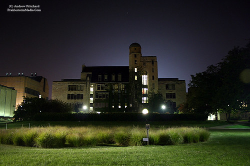
September 8 2009 - Northern Illinois University campus
Not the best capture of the ISS and Space Shuttle passover, but significant in that it was also my first photographic journey as a student at NIU in DeKalb.


August 19 2009 - Approaching the Rochester, IL tornadic storm.
This might not be much of a significant chasing photo to others, but I've always liked it. I've really enjoyed sharing chases with Tia over the last few years. It started with her simply wanting to spend time with me, but she's admitted to finding things pretty interesting and has learned really fast! She's become quite the navigator and has kept me cool in some insane situations. I've been known to blow a gasket or two, but don't seem to reach that point with her in the passenger seat, even in a year like 2009.


July 25 2009 - Urbana, Illinois
Lightning illuminating the under side of a late night bow echo moving into the Champaign-Urbana metro. The very first "intercept" for the new Mazda6, even though I only drove 1.5 miles!


November 8 2009 - DeKalb County Windfarm
I think we're staring to see a theme here, yeah? Another balmy fall evening, I had to venture out to the wind farm again and snagged this shot at twilight. Probably my favorite shot of the year.

Sunday, December 27, 2009

Merry (late) Christmas!

Well, central Illinois finally got their snow. I'm a little bummed I missed the ice event in DeKalb on the 23rd (caught the early stages before I bailed out down I-39 to CMI) and the whopper snow accumulations that occurred yesterday in northern Illinois but at least I've got a little white stuff to amuse myself with down here finally. Just finishing the observations for WILL in Urbana where I'll be reporting 3.8" for the last 24 hours and a snow depth of 5 inches.

The Christmas holiday went well over here. Since moving up north, I finally get to experience "coming home for the holidays". I managed to pick up a couple new things for the coming storm season. Notably a spiffy new external microphone for my HV30, and some cash for my most exciting new toy in the Sigma 10-20mm lens for the XT. I trust all four of my trusty readers had a fun filled holiday weekend as well!

Saved a few fun images from the massive Christmas storm that I figured I would throw up here. What a massive storm it was, not only in intensity but sheer size.

Water Vapor Imagery:


Infrared Satellite Imagery:

Saturday, December 19, 2009

Snow Video

Okay, I lied about the video. Here it is, in all it's glory.

Five minutes you'll never get back!

Wednesday, December 9, 2009

Wind and Snow at NIU

Decided to venture out and took a few photos and some video on the Northern Illinois Univ. campus once the winds arrived and some more snow began falling. Took some photos of the suckers walking to their exams in this stuff. Though, who's the bigger sucker, the people who are walking to exams or the guy out there for fun. I'll be the biggest sucker of all tomorrow when I'm walking to my exam and the temperature is oh, -5F or something like that.

Probably won't put up any video, as it's not exciting enough for the time right now as I have studying to do but here are a few photos.


Here's a pretty sweet image from around the time the low passed directly over us here in DeKalb. Barometer at the airport dropped to 28.90". Wonder how many times that has happened.

Crappy Snow Time Lapse

Made a quick time lapse yesterday, though it really doesn't show anything cool. We got about 6 inches, but you can't really tell that in the images. I suppose if you watch the roof next door or something you can see it mount up. Heaviest snow comes from the convective bands that we experienced midway through the video. Rates probably hit 2 inches per hour for a short time.

Kind of a bummer thus far, though I guess a fun first system for the winter. Six inches and 30 mph wind gusts is not really that atypical for this location in December. Surface pressure did hit 28.90" last night, which is pretty impressive. Wonder when the last time that occurred around here. Temperature is still holding at 29F but that won't last. Subzero tonight is the plan, so I guess if I'm going to take any photos of the snow I should do it now.

Monday, December 7, 2009

Snow Streak / Upcoming Storm

Caught a nice burst of snow on Thursday night (technically very early Friday morning!). Was heading to bed late that night around 2 a.m. and was surprised to peak out the window and see the ground covered in a white coating. I thought the flurries were more or less done with but we were actually experiencing a fairly high snowfall rate at the time, which lasted about an hour. The snowfall showed up on visible satellite images the next morning and showed just how thin the snow band was, and what a direct hit we experienced here in DeKalb.


Crappy cell phone picture of snow covering the east quad on the Northern Illinois Univ. campus.


Looks like a decent system coming in a couple days on Tuesday evening / Wednesday morning. The real threat appears to be blowing snow at this point. DeKalb seems to be bordering on getting pretty close to the rain/snow line with this one as the low pressure track settles in. At this point I'd venture to guess 6 inches of snow is not out of the question here, give or take 6 inches! If we do get a few inches at least, the main issue looks to be the winds on the back side of the system which could take only a couple inches of snow and create a white out situation in a hurry. Temperature will also take a nose-dive into Thursday. Luckily, I will be able to enjoy the mass chaos on Wednesday, but then bail south to Champaign-Urbana on Thursday where there will be no snow cover to deal with! That's about as close to a winter storm perfect world as you can get. I'll enjoy whatever fun mother nature brings, but then be able to avoid driving around a snow covered town for weeks!

Monday, November 30, 2009

Thanksgiving / Lightning

Well, Thanksgiving weekend was a success on my end. Hopefully all was well on everyone else's end as well. My first Black Friday experience was a success. Tia and I waited for only about 45 minutes in the cold until 4 a.m. when Sears opened. From the time the doors opened, til we had the items and had checked out successfully only 8 minutes passed. I looked at my cell phone to see the time as I was walking to my car to pull it up to the door and it was only 4:08. I call this, great success. If only we had that much success chasing together this season! We browsed a couple other stores for the hell of it since we were already out, and returned home and were in bed by around 6.

On a more "chasing" related note, I finally got around to playing with some old video this weekend. I had always wanted to do a higher quality upload of the August 22nd 2002 lightning bolt that I captured striking a tree 17 yards from the camera during an insane lightning barrage. I don't think I've ever encountered a more electrified storm. For about 30 minutes we constantly took cloud to ground bolts within 100 yards. Just watch the video clip below. After the initial strike 17 yards away, the camera falls to the ground, but you can still make out the flickering from the following bolts. There are a good 3 or 4 additional strikes with near simultaneous crashes of thunder. Never seen anything like it!

As seems the norm around the web community, I'll be spending the next couple months updating old logs. Since buying my current domain in late 2007, I had not moved everything from the cheapo geocities domain I had hosted everything on previously. Without warning (that reached me!) geocities was discontinued and I lost everything prior to 2008's season. I guess that's the final motivation I needed to update everything! Some will be lost for good though I suppose, as I'll likely only replace those worth replacing as I simply don't care to do 25 logs a year dating back to 2001/2002 when I first started getting out there regularly. However, those that I do replace I hope to do a little more in depth than I previously had. I won't be able to do near the detail in my chase summaries after so many years but I'm going back and gathering radar images and other such data to try and give a little more background on each day.

Anyway, as promised:

Thursday, November 26, 2009

Thanksgiving!

Updating for the sake of updating here. Happy Thanksgiving to all 4 of my readers out there! Did a couple Thanksgiving meals with family here in the Champaign-Urbana area this afternoon or evening, which was delicious as usual.

I'm actually having my first ever Black Friday experience in a few hours. I'm actually getting really excited to dominate some shoppers with Tia at 4 am. I don't have anything that I'm actually interested in purchasing, but Tia found a couple deals that she wants to snag so I'm going to team up with her to conquer a store or two before returning home to join the rest of the sane world in dream land.

Clearly no weather news to update on here. Thought we might see our first flurries of the year in central Illinois, but that wasn't the case in the C-U area at least.

Sunday, November 8, 2009

Wind farm at twilight

Figured I had to enjoy the 70F temperatures out there. What better way than a photography trip. I had no idea where I wanted to go, but gassed up the car and grabbed a 32 oz. Coke and was on my way. I left DeKalb and quickly decided I wanted to play with the ever expanding wind farm just south of town. Here is what I came home with.


Wednesday, November 4, 2009

PWX 2009: A Tale of Two Seasons

Well, a typical late release on my end, but it's finally here.

The next in the line of PWX 20XX storm chasing DVDs, PWX 2009; A Tale of Two Seasons features the beautiful, and the very ugly sides of storm chasing in the central United States. 2008 featured one of my most successful two week periods in the end of May and first week of June including the western Kansas events on May 22/23, culminating with the June 7th wedge-fest in northeastern Illinois. I came out of the gate sprinting in 2008 and fell flat on my face in 2009. A very difficult year for storm chasing which did still prove fruitful to some was unrelenting on my end. If I wasn't being hosed by mother nature, it was such inconveniences as a totaled car in a construction zone. PWX 2009 is packed full of 2008 action, and 2009 pain (and I suppose a few nice storms as well!).


Charging $15, shipping included. Any chasers out there wanting to trade can shoot me an email.

All the information can be found here: http://prairiestormmedia.com/PWX2009.html

Tuesday, October 20, 2009

DVD Production

The 2009 DVD is about 90% complete. For the bad luck that I faced this spring, I'm pretty happy with how this one is turning out. It helps that my DVD's always cover the current year, and previous year and I wound up having an excellent 2008. The crappy luck this year kind of played into the theme for the DVD which wound up being "A tale of two seasons". Just watch how quickly your luck can change out there!

Saturday, October 10, 2009

Help Needed...

Figured this should be posted here as well. Some may already be aware of the situation, but might not be aware of the new method to help out here. If you had not heard, good friend and fellow chaser Darin Brunin and his girlfriend Alexis Sullivan lost their apartment the other night during a lightning induced fire. Dick McGowan has set up a method for donations to them, so I will let him finish the talking:

"As some of you already know, yesterday morning, Darin Brunin and his girlfriend Alexis Sullivan, were woken up to a fire that was triggered by lightning in Lawrence, Kansas, which consumed the top apartments where they lived and left their apartment uninhabitable. Fortunately, two good samaritans rang all of the resident's door bells in the building, giving them all enough time to escape, unharmed. Here is a link to the story.

According to the fire department, they have lost pretty much everything and unfortunately didn't have any insurance. They both have received support from the Red Cross and have been temporarily moved to another apartment, but still lack a lot of essential goods for their new home (including clothes) . It is to my understanding, that they will not be able to return to the apartment to see what's left/salvageable for another week, until a structural engineer evaluates the scene.

Unknown to them, I am asking anyone who wishes to contribute to their devastating loss, to send funds to my paypal address: midwesternmeso@hotmail.com

You may also email myself at the same address to give Darin and Lexi any support or encouragement, and I will pass it along to them. If you wish to donate anything else, please PM me or email me and I will send you an address to where you can send something.

If you can not do this, I fully understand (as would Darin and Lexi). Thank you so much to everyone who have already given their sympathies to Darin and Lexi; they are both thankful for all of those who have been so kind to them and have given them the support they need."

Tuesday, October 6, 2009

Shabonna State Park / Twin Groves Wind Farm

After a rough Monday, I had most of my Tuesday evening free so I decided to take off for a drive around 4 PM. Ended up meandering my way to Shabonna State Park. It was windy and chilly, but what are you going to do? It will be a whole hell of a lot worse in a month or two. After the lake, I wound up back at the Twin Groves Wind Farm near Interstate 39. Still don't understand how some can protest these things.


Thursday, October 1, 2009

Another Time Lapse

On a cool, dreary evening with dashed severe weather hopes in the central US, there's nothing better to do than to time lapse an old favorite.

This would be the evolution of the minisupercell near Manchester, Illinois on June 3rd 2008. This thing didn't stand a chance, with almost no surface flow to speak of. However, a morning bow echo left an outflow boundary draped across central Illinois and this storm was able to take full advantage.

Why late season chasing sucks.


YES!


Damn it.

No I did not chase today, however. Desperate as I was, this one wasn't worth it no matter how you tried to swing it.

Wednesday, September 30, 2009

Another Pointless Low Cape Chase Forecast

I know some a pretty in to the 4km simulated radar output, so I figured it's worth mentioning it seems pretty keyed up about tomorrow. Forecasting supercells along the warm front in northern Missouri and potentially western Illinois, along with potential tornado producers along the cold front from Chillicothe, MO southward into northern Arkansas.

This seems fairly in line with what I was predicting earlier in this thread. Not sure how realistic the scenario is, as it still goes largely against the NAM and GFS solutions which are very against producing any sizable cape aside from the jungles over southern Missouri and Arkansas.

Springfield, Missouri looks to be in the line of fire once again. I'd look to this area along north-south Highway 65 in central and southern Missouri to be potentially under the gun tomorrow from 3-6 PM. Earlier in the day, I still would not rule out a few tornado warnings / reports along the warm front in northern / northeast Missouri, near Kirksville and then potentially even into portions of western Illinois. That second area is a really big *if* right now, and will require very close monitoring of real time data once tomorrow rolls around.

Here's a crude image to go along with my thoughts. Making these always seems to jinx my forecast, but here goes.

Everything looking down!

Looking at the NAM and GFS forecasts for tomorrow, things look absolutely done for.

I'll continue to watch this system however, as the dynamics themselves warrant it. Large amounts of early morning convection are the culprit for putting a damper on the tornado chances with this system in the northern sector. Our biggest hope, is that this is being slightly over forecast, and that with the rapid deepening of the cyclone most of the early waa precipitation is quickly lifted northeastward out of the potential target area.

If this scenario is realized, I think northern Missouri would warrant some attention. Just ahead of the surface low and near the warm front, low-level shear profiles would lend themselves towards updraft rotation. Should early day convection be lifted out of the area soon enough, and some insolation can occur a broken line of supercells across northern Missouri southward does not seem unreasonable. The Chillicothe, Missouri area would not be a bad place to be in this scenario.

Just hard to accept a 500mb prog like this would go to waste.

http://weather.cod.edu/forecast/WRF/...500_spd_36.gif

Of course, this is hoping for a lot and going largely against what model data is showing. I think it warrants careful observation through tomorrow morning, however.

Tuesday, September 29, 2009

I have been served.

Another flame war broke out on Stormtrack yesterday evening. I decided to jump into this one, mainly because it was a slow, dreary, blustery Monday afternoon. Mid-war, I was served.


I really lost interest in the flame-war quickly though. However, I saw several involved calling for blood even as night fell. I find these events to be hilarious, personally. Getting so worked up over trivial things, I just love sitting back and throwing in minor attacks. I guess it's the immature child in me acting out, and apologize for the trouble it causes the admins at ST, but I always have and always will love a good flame war on that forum. There is nothing like it to get you through the off-season.

I guess it's just a big reason why I hate other storm chasers. I associate with a very small group who I've grown to know and trust through the years. Those people know who they are, of course. Just seems most out there love to talk big talk, but then get offended and play the victim when the feathers they were ruffling strike back. But seriously, talking "big talk", about storm chasing. Really? Of all the things to talk big about, storm chasing to me just seems hilarious. I'm sure there are other nerds out there, like volcanologists, talking smack to each other threatening to "throw down" on top of the next active volcano. Or geologists telling other geologists they better not show up to that next big dig or they're going to get pummeled. Meh. Perhaps I'm an asshole, but this whining is why I don't really care for chaser networking, and even have a lot of the "chasers" out there "Hidden" on that big social networking site that EVERYONE is a chaser on.

I've written a lot about a topic that I don't care that much about. I'll run off for now and contemplate more meaningful things, such as why storm chasing in Iowa on Thursday would be a bad idea.

Monday, September 28, 2009

Severe Midweek?

Probably not, and I've been trying to ignore it as best I can. Thursday has my attention purely based on the dynamics of the system. It appears, as is per usual with early spring and fall setups that we'll be dealing with little, if any instability. The prime target looks like it will be located in the state of Iowa, to make situations worse.

The only area of interest that I see right now, is where ever the low ends up. If you can get a narrow tongue of instability to feed in there, I have a hard time believing supercells would not be likely given the wind fields. That instability existing is however, pretty unlikely. That potential "best area" is also hugging a major river valley. I'll watch southwest Iowa for now, I suppose.

Tuesday, September 22, 2009

Links Section

I finally got around the the five minute process of adding a link section on the blog. I'm going to keep the links section on here to blog content only for now. If you've got a weather blog, and I halfway know who you are and want to swap links let me know. I've already added a few people who I have corresponded with in some way or another and could think of their blogs off the top of my head.

The gnat problem is expanding exponentially here in DeKalb as well now. What is going on??

Monday, September 21, 2009

I take it back...

Whatever I said last week about this weather being boring, I take it back. I can't get enough of this beautiful weather and perfect temperatures. Three weeks straight of high temperatures around 75, with crystal clear nights with temperatures hovering in the 50s. I was driving back to DeKalb from Champaign last night around midnight with the all the windows down, in a foggy 60 degree night and wondered how much better that could get. Yeah, I could be driving home after bagging a tornado with a lightning illuminated drive home with a Day 2 moderate risk on tap for the following day... but let's be real. In mere weeks and months, I'll be fighting sideways falling snow and face burning cold temperatures so for now, I don't want to change a thing.

The severe weather prospects for this fall still look like a snooze-fest. At least the coming weeks. That big cut off low will just continue to churn away for a few days before finally pushing out at the end of the week. One could hope for a thunder chance once it pushes through around Friday and Saturday, but let's not get ahead of ourselves. I'd love to get in another chase or two or three before the snow starts falling, but for now I'll eat this beautiful weather up.

I'm still watching my Cubs. The playoffs are all but mathematically impossible now, so that's not my motivation. Along with the weather, I'll watch these last few games just because I know how much I'm going to miss this once it's gone. I love college football and basketball, but there is just nothing like a 162 game season of Chicago Cubs baseball. The only thing that comes close to that for me is the March Madness period of the NCAA Basketball season. That's just a kick off party for baseball and storm chasing season, anyway!

Also, what's with the gnat issue in central Illinois. Things are just starting to settle in here in DeKalb, but they've got an all out plague down closer to Interstate 74. Champaign, IL is in a constant swarm of the little pests. I'm heading back down that way on Wednesday, so I'll try and get a little photo or video evidence of the issue. When you get the right angle with the sun, it looks like it's snowing fairly heavily. Forget about riding your bike or anything outside or they'll be plastered to every forward facing portion of your body.

Cubs lead 7-0 on back to back home runs, and on that note I'm off.

Tuesday, September 15, 2009

Another slow fall evening

I wonder, could this weather pattern get any more dull? Three weeks ago I was complaining about the steady rainfall that we saw the final week of August and how the only thing I wanted was to see the sun again. Well, I don't think the sun has stopped shining since that day. I guess I'm not complaining. The weather -has- been beautiful after all. In January I'd probably smack myself for whining about a weather pattern that brought nothing but clear skies, highs in the upper 70s and lows in the mid 50s. A little something to look at would be nice, though.

Sitting here watching another Cubs game (no, I have not given up hope yet.) and doing a little updating on the main site. There's not a lot to update, but there's always something that's behind. I finally switched the "Vehicle" page over to the new Mazda. The car is turning out to be a real find, as of now. I loved the Stratus R/T, but things probably could not have worked out better from where they stood in late June of this year. I guess after the shit storm that this chasing season turned out to be, finding a new car to fall in love with and starting classes back up was just what the doctor ordered.

It's getting to the point where I start thinking DVD. I was thinking about just not doing one this year. But, I would probably just start making one anyway because I love putting them together too much. I didn't see any highly visible tornadoes this year, but I did have enough cool storm intercepts to make a few interesting segments and perhaps time lapses. That coupled with a good 2008 should make enough for me to allow myself to put out another in the PWX 20XX series. I don't see any reason to look forward to an active fall right now, but I will hold off on making the DVD just in case until my usual November release time frame.

Wisconsin was nice last weekend. The weather was beautiful, which made up for a chilly lake. The water temperature was still in the low 70s, so I spent plenty of time in there. Scott Weberpal and his girlfriend Kelly came up for the day on Saturday to check the place out. We spent the evening at a local bar / grill that sits on a neighboring lake and watched the Wisconsin vs. NIU football game before coming back to enjoy a nice fire.

Friday, September 11, 2009

The house.

Well, I've been living here in DeKalb for several weeks now, but never really felt compelled to post anything about the house I'm in. I'm pretty bored at the moment on a Friday afternoon, waiting on Tia to head up here so I went around and took a few photos.

Here's the outside of our place...


And then a couple shots of my room. It's somewhat bare right now, but is fully functioning!


The Cubs are always on...


Where I'll be emptying my bladder in about 5 minutes:


The livingroom:


Diningroom:


Couple shots of the kitchen:


Our little backyard patio / eating area. Okay, so the yard is not a patio... but we do have one behind where I'm standing, and we'd moved the patio under the tree to eat dinner the other night.

Tuesday, September 8, 2009

ISS / Discovery Flyover

I was made aware about an hour ahead of time that the International Space Station and the Space Shuttle Discovery would be flying overhead and visible in tandem over the Central U.S. around 8:15 PM CDT this evening. I ventured out to the Northern Illinois Univ. campus around 7:45 and putz'd around photographing some of the buildings on my end of campus before the two came into view.

First, of course, the main attraction. ISS and Discovery in tandem, flying over the Davis Hall observatory here on the NIU campus.


I figure I'll share a couple of the scenes here on campus while I'm at it. They're nothing special, but killed the half hour before the main event above appeared.

Altgeld Hall. Mr. Altgeld himself, back in the day, decided he wanted one building to unify all Illinois state schools, and wanted them all to have a castle. So, Northern Illinois University, University of Illinois, Western Illinois, Southern Illinois and Illinois State Univ. all have one... sorry Eastern. For whatever reason EIU decided to skip out.


Sven Pearson Hall, The Law Building with the Holmes Student Center in the background.


And then a couple from Davis Hall, where the Meteorology Dept. houses itself. I have not yet made it to the observatory on top, but will soon.