Managed another decent chase yesterday. As I had a hunch, the models where way off on handling yesterday's setup. Seemed the models were keeping thing way too far south, so I kept my day open. Sure enough, around 4 PM cells rapidly fired across central Illinois, and I picked one off around Clinton. Followed it for it's entire track across eastern Illinois, letting it go near the Indiana border watching it's backside as it scooted away. The storm wound up pretty tight a couple times, but struggled with being elevated much of it's life span.
Not a bad chase op at all though. I've seen two great supercells in two days without filling up my gas tank, and still have over a half a tank left.
Tomorrow is a tough call. I think there will be tornado reports, and it's obvious they'll be on the warm front, but they could end up anywhere from central Illinois (maybe even western Indiana) all the way to southern Nebraska. I'm inclined to say southern Iowa looks the best right now, right along the IA/MO border, but western Illinois looks half decent as well and I'd never let it go if I missed the only Illinois tornado show of 09 because I was in Iowa. It is Iowa though, so it will produce if I don't go, and won't produce if I do. Right now my gut says the best parameters are over southern Iowa, and my brain says "Don't do it, Illinois will find a way to go nuts the second you cross the River". I guess I'll decide tomorrow.
Target in Illinois would be the Peoria area, and in Iowa I'd do the Creston to Osceola area.
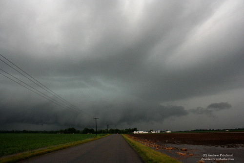
Couple photos from yesterday:
Wall cloud near Arcola, IL exhibiting the best rotation of the day:
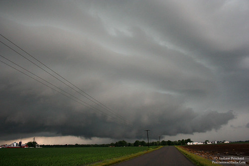
As I had hoped, what storms formed yesterday were very photogenic! Stuck to my plan and only chased what came locally and wound up with a pretty minisupercell just 15 miles from home in southern Champaign County near sunset. The storm tracked southeastward, developing a wall cloud near Tolono, and then becoming a pretty striated storm further south in no man's land.
Not holding my breathe for any chasing today, though I'll be keeping an eye in south central Illinois this evening. Looking at the models I'm fairly convinced any supercells that form should be over far southeast Illinois, southern Indiana and Kentucky. However, looking at real-time data, I would not rule out a decent storm or two in central or south central Illinois. Probably along a Bloomington to St. Louis line early, and then moving SE into southeastern Illinois. I'll keep an eye on it though, and should it appear we'll get development far enough north and west I may poke around. A couple friends of mine asked if I'd be around to film their new band's first show this evening so unless it appears things may go tornadic I'll probably choose to sit this one out. Monday and now even Tuesday continue to look more interesting, and over chaseable areas of the midwest. Today looks like a good day to watch from the laptop, with the Cub's on t.v. starting at 3:30!
Here are a couple photos of the minisupercell from yesterday evening...
Looking for a couple thunderstorms to pop in central Illinois this evening. Not looking at widespread severe weather, and certainly not a tornado event (disclaimer: stranger things have happened.)
Dry air will prevent too much in the way of severe weather, but could actually lend itself to some photogenic opportunities on any storms that do develop. I'm not chasing this one, but will watch for any local development and a potential jog through the country to shoot some convection. I'd look for a couple storms between Decatur and Danville around 6 PM. Nothing too impressive but a couple severe thunderstorm warnings primarily for hail seem possible.
Looking further out it seems increasingly likely that we'll see another round of thunderstorms with isolated severe reports primarily of the damaging wind variety early tomorrow morning. These should push into the NW portion of Illinois before sunrise, and affect central IL in the late morning hours.
Sunday, any severe threat will probably be west of this area in Iowa and Minnesota, with very isolated storms possible further south into Missouri. I'd look for Monday for our next good severe weather event. Details are unclear at this point as to severe coverage and storm mode, but Iowa, northern Illinois and southern Minnesota and Wisconsin look to be the main targets for this one.
I think we've got more of a mid-late June pattern taking effect here, which is really going to favor two areas. Those two areas being the upslope flow along the Rockies, namely in central/eastern Colorado into western Nebraska and Wyoming and the other being the midwest in areas from the NE/IA/MN/IL corridor.
Their should be several good days along the front range of the Rockies where upslope flow interacting with any shortwaves ejecting eastward could net some sculpted supercells and potential landspout play for high plains chasers.
Further east we'll see the late June style pattern set in, with a stationary boundary stretching from Nebraska into the mid-Mississippi valley under at times very favorable NW flow. Typically you'll see a severe threat anywhere along this stationary front as it wobbles north and south, being enhanced by any embedded shortwaves in the NW flow, and any outflow boundaries from overnight convection. It's certainly not everyone's first pick, but you can come away with some beefy supercells early on from these setups, often of the HP variety. It's not the first choice for tornado viewing, but can be fruitful from a convective standpoint. The Interstate 80 corridor from Grand Island, NE to Chicago, IL is often a good place to be during a pattern such as this.
We'll see how things play out. Late May and early June instability will be in place, but whether we get some good waves embedded in the NW flow will be the key. Already looks like a potentially good day in eastern Iowa on Friday if enough moisture can arrive in time behind this tropical low that's finally moving on out.
Hadn't really planned on chasing anything yesterday, but knew the tropical low remnants would be in the area, so I kept one eye on the forecast models hoping for a little more deep layer shear. I woke up to see an MCD from the Storm Prediction Center discussing possible brief tornadoes in south central Illinois and eastern Missouri. I took a look at the current data (as it was already noon) and sure enough, there was some sort of convergence boundary firing off rounds of thunderstorms, that interacting with the low level shear and warm front associated with the tropical low were getting some spin and producing at least a few funnel clouds. You know you're in trouble when you have to validate your own reasons for chasing to yourself, but I had all this time off FOR chasing so I might as well try and chase -something- in this dreadful pattern. My target was only a little over an hour away, anyway. It was certainly worth the drive if something were to happen.
En route a couple tornado warnings were issued for cells in my target area, right along Interstate 55. I targeted one area that seemed to continually regenerate convection in the same area, producing funnel clouds. Certainly things seemed to be coming together in this area. There was a very good bullseye of the lovely 0-3km Cape/Surface Vorticity in this area, 2000 j/kg surface based cape and a little patch of 200 m2/s2 low level helicity. Winds were due east along the warm front. Nothing above 800 mb however, so sustained convection would be hard to come by.
I intercepted my first cell near Litchfield. Despite it's piddly radar appearance the storm had a decent rain free base with low level inflow bands feeding into it. Low level clouds had eroded so I had a nice view of the entire storm, RFB up to the updraft tower. This storm wasn't around long though, as it quickly dissolved into nothing.
I dropped south a bit more, to an area near Staunton, where I was treated to a dying LP-type storm. Despite a healthy, but small rain free base, this storm also was not around long.
I saw more substantial returns showing up near Vandalia moving my way, but their shape was not supercellular at all. This was about the only show in town anymore though, so I not so happily plotted my intercept. Dropping down Highway 4 in Macoupin County I got visual of a newly forming storm. This one had "the look". It's precip core on the northern end was very dark, and had a very thick inflow tail feeding into it. The other thing that I noticed, the surface winds which had been very light the entire day were now screaming eastward into the storm at sustained 25 mph. A look like that, with inflow such as it was pulling in prompted me to stop before the storm's radar appearance really showed anything substantial.
I dropped south to the Highway 4 and Highway 138 junction near Marine, IL where I got a view of the RFB of the new supercell. This one really took off, with a nice black base, with an inflow tail quickly developing and feeding into it on the northern end. Several times I thought it might produce underneath. However, the problem today was way too much convection. Shortly after really tightening up, a small cell was quickly pulled into the main supercell's eastern side. This obscured any view of the base, and required a regrouping phase before things got back together. I wondered if this would be the end of my cell, but radar and visually it became apparent that it would try again once the smaller cell was successfully absorbed.
I repositioned north on Hwy 4 and west on Fruit Road, just east of Edwardsville where the storm really took off. It was now a well organized, striated supercell. The entire updraft base exhibited broad rotation. Very organized low level rotation however, was never achieved. While it looked good a couple times, it was never able to come truly close to tornadogenisis before again, a smaller cell would interfere with it's inflow.
The supercell regrouped one more time, but was very elevated and showed no further signs of being of any threat other than heavy rains so I bailed on it and plotted my way home. I was treated to a nice sunset, followed by a nice crescent moon between low level clouds as I listened to the Cubs lose their 8th straight game on my way home.
It was no an ideal chase for late May, but in a down year such as this I'll take what I can get. Any other May, and I probably don't give this setup the time of day. But, lack of anything at all on the forecast models, and all this time set aside purely for chasing netted a decent surprise down there.
A couple photos, and a timelapse video.
The slow timelapse shows the problems that this supercell faced with interfering convection. Watch in the first half, as my first view of the storm's rain free base is slowly obscured by a gray haze as the smaller cell is absorbed.
Got a couple lame video clips up from the last two chases.
The first is from the May 13 2009 chase in northern Missouri. Hung back too long and missed the big tornadoes, however one almost had to get hit by the tornado to see anything so I'm not killing myself over missing the action Wednesday. Did get a good wall cloud with condensation fingers at least.
Second here is from the Interstate 72 corridor HP supercell from near Springfield to Champaign, as it became a bow echo. Never came super close to producing a tornado as it remained rooted on the cold side of the boundary, but we did get a couple good areas of rotation, and some gusty erratic winds as the mesocyclone passed overhead.
After Wednesday, I'm ready for some weather revenge.
Looks like a classic warm front day in western and central Illinois this evening. Abundant clear skies south of the warm front should allow rapid destabilization and a northward surge of the front this afternoon. Should be around Interstate 72 by around 4 PM. Will be key in getting a supercell to initiate and latch on to the warm front, but should it do so, classic hockey stick hodographs would certainly favor tornado development.
I'd watch the Interstate 72 corridor from Jacksonville to Decatur this evening.
This is phenomenal. A severe weather setup has shown up on the models at long range, and now only 48 hours out is still there. Not only that, but I believe a fairly significant severe weather threat may exist over parts of Illinois and Missouri.
Looks like the "classic" outbreak zone of east central Missouri into central Illinois may be the hot spot for another active day.
Current thoughts remain more or less unchanged as of a couple days ago, which is a good sign. I hate multiple target days, as I often second guess myself into missing things, or just waiting too long to commit. This time, at least 48 hours out, I'm sticking to my guns and it will just be up to the weather to prove me right or wrong.
There will be a ton of convection in IL on Wednesday. The bulk of the main complex should track east into Indiana by early afternoon, allowing for clearing behind it, along the E-W boundary laid down. I'd look along this boundary in EC MO and SW IL for new supercellular development. Likely around Columbia, Missouri, tracking into western and southwestern Illinois. A high cape / theta-e area will be nosing into this area with sbcape nearing 2000 j/kg. That along with helicity values above 350, nearing 500 closer to Interstate 72 will be more than adequate for discrete thunderstorms (talking ahead of the cold front here, folks) and potentially tornadoes. There will be a strongly forced line of thunderstorms along the cold front by nightfall, but I don't intend to be anywhere near the cold front during the chase.
I'll continue eyeing an area in SW Illinois near Litchfield, along Interstate 55 south of Springfeld and north of St. Louis.
Looking increasingly likely that there will be some severe weather event across the midwest on Wednesday, May 13th. Strong dynamic system has been showing up consistently on the forecast models for quite some time now.
Still 78 hours for things to go wrong, but right now it's looking like there could be a decent tornado event across eastern Iowa, Missouri and all over Illinois. As such with these dynamic systems, questions to be answered will be the amount of morning precipitation and cloud cover. These things generally work themselves out however, and if things play out the way they appear now I'd expect to see tornadic supercells across the three state region Wednesday evening.
As typical luck would have it, I do have a final exam that day. However, I will be done no later than 1, so should it stay in the location shown now I -should- have no problem getting into position by initiation time, or shortly thereafter. If storms are firing before that time, it will likely not end up being a huge event anyway. Typically you'll want the cap to hold off any thunderstorm development til around 3 or 4 to get maximum instability. With a strong dynamic system that is especially key, as with too little instability and too much shear you'll end up with garbage that never organizes.
We'll see how future model runs play out, but for now I'll eyeball west central Illinois, early Wednesday afternoon.
With the forecast models being in their current state, talking about this is probably ill-advised. However, I'll mention anyway that I'm seeing a possible warm front event in the midwest on Thursday afternoon, May 7th. The current area to watch at this point looks like northern Missouri around Kirksville, east towards Champaign, Illinois and then south to Interstate 70. Basically most of central Illinois and northern and eastern Missouri.
Model trends will have to be monitored, and this setup could very well vanish by tonight's run. However, looking at a combination of models, current data and trends, and climatology I feel this bares watching. Thunderstorm clusters will be likely early in the day and will largely affect the overall thermodynamic profiles, but may also aid the situation with associated boundary creations. Hodographs will already be largely curved along the warm front which would support supercell thunderstorms and mesocylone development.
I might as well stop here, because the current pattern is already very unstable and changing constantly, but figured this was worth mentioning.
PrairieStormImagery.Com
Blog of Northern Illinois University Meteorology undergraduate and storm chaser Andrew Pritchard. Supplement to the PrairieStormImagery.Com site. Meteorological musings, and non-related discussion generally focused on the beautiful imagery the Earth's atmosphere provides.