
En route a couple tornado warnings were issued for cells in my target area, right along Interstate 55. I targeted one area that seemed to continually regenerate convection in the same area, producing funnel clouds. Certainly things seemed to be coming together in this area. There was a very good bullseye of the lovely 0-3km Cape/Surface Vorticity in this area, 2000 j/kg surface based cape and a little patch of 200 m2/s2 low level helicity. Winds were due east along the warm front. Nothing above 800 mb however, so sustained convection would be hard to come by.
I intercepted my first cell near Litchfield. Despite it's piddly radar appearance the storm had a decent rain free base with low level inflow bands feeding into it. Low level clouds had eroded so I had a nice view of the entire storm, RFB up to the updraft tower. This storm wasn't around long though, as it quickly dissolved into nothing.
I dropped south a bit more, to an area near Staunton, where I was treated to a dying LP-type storm. Despite a healthy, but small rain free base, this storm also was not around long.
I saw more substantial returns showing up near Vandalia moving my way, but their shape was not supercellular at all. This was about the only show in town anymore though, so I not so happily plotted my intercept. Dropping down Highway 4 in Macoupin County I got visual of a newly forming storm. This one had "the look". It's precip core on the northern end was very dark, and had a very thick inflow tail feeding into it. The other thing that I noticed, the surface winds which had been very light the entire day were now screaming eastward into the storm at sustained 25 mph. A look like that, with inflow such as it was pulling in prompted me to stop before the storm's radar appearance really showed anything substantial.
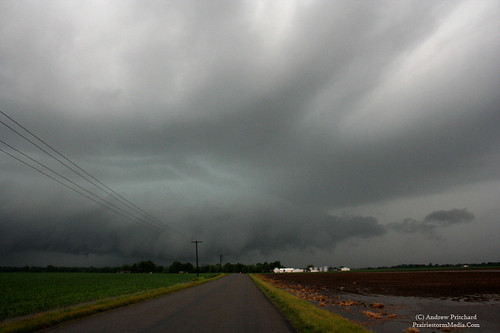
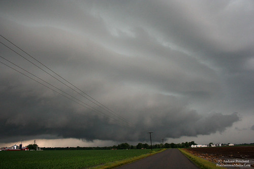
I dropped south to the Highway 4 and Highway 138 junction near Marine, IL where I got a view of the RFB of the new supercell. This one really took off, with a nice black base, with an inflow tail quickly developing and feeding into it on the northern end. Several times I thought it might produce underneath. However, the problem today was way too much convection. Shortly after really tightening up, a small cell was quickly pulled into the main supercell's eastern side. This obscured any view of the base, and required a regrouping phase before things got back together. I wondered if this would be the end of my cell, but radar and visually it became apparent that it would try again once the smaller cell was successfully absorbed.
I repositioned north on Hwy 4 and west on Fruit Road, just east of Edwardsville where the storm really took off. It was now a well organized, striated supercell. The entire updraft base exhibited broad rotation. Very organized low level rotation however, was never achieved. While it looked good a couple times, it was never able to come truly close to tornadogenisis before again, a smaller cell would interfere with it's inflow.
The supercell regrouped one more time, but was very elevated and showed no further signs of being of any threat other than heavy rains so I bailed on it and plotted my way home. I was treated to a nice sunset, followed by a nice crescent moon between low level clouds as I listened to the Cubs lose their 8th straight game on my way home.
It was no an ideal chase for late May, but in a down year such as this I'll take what I can get. Any other May, and I probably don't give this setup the time of day. But, lack of anything at all on the forecast models, and all this time set aside purely for chasing netted a decent surprise down there.
A couple photos, and a timelapse video.
The slow timelapse shows the problems that this supercell faced with interfering convection. Watch in the first half, as my first view of the storm's rain free base is slowly obscured by a gray haze as the smaller cell is absorbed.


No comments:
Post a Comment